Friday 19/7/2019 at 08:45
Guided excursions

Guided excursion Monte Fior and the Melettes, between history and geology of the plateau with GUIDE ALTOPIANO - Mountain Professionals
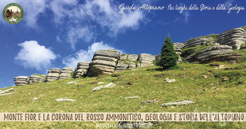
Mount Fior and the Melettes of Foza between 1916 and 1917 will be at the forefront. In 1916 the first Battle of the Melettes and then in 1917 with the battle of arrest, the whole territory will be the scene of bloody clashes. Today, however, peace and tranquility reigns, sheep and cattle graze and the meadows are no longer battlefields, but lush huts.
The characteristic "Rock Crowns" of ammonitic red in contrast to color with the verdant pastures make the area unique. From Mt Fior 1824 m.s.l.m. we will enjoy an exceptional vantage point where our gaze can range in 360 degrees. To the west the Altopianese conca with Gallio in the foreground, then Asiago, Camporovere, Canove, as well as a magnificent overview of the entire high area, Portule, Cima Larici, Cima XI and XII, Ortigara, Calidiera.
On clear days you can see the Brenta group and the Lagoraichain. To the south the village of Foza, the Brenta Canal and at the bottom, as Emilio Lussu also wrote in "a year on the Plateau" .. Venice. Venice!
Everywhere you can still see the remains and traces of the war that between 1916 and 1918, shocked our countries and our mountains; now recovered and included in the project "Ecomuseum of the Vicentine Prealps" – The Places of War and Literature-.
EXCURSION SCHEDULE:
Expected reunion:
1. 8.15 a.m. at Foza Church
2. 8.45am from the Bar to the Station near the entrance to the Piazzale of the Asiago Ice Stadium.
Duration of excursion: 4 hours including the guided tour
Difficulty: AVERAGE (Read below the description of the difficulty)
Level: 250m
COST OF EXCURSION: GUIDED TOUR
Adults: 15.00
Children up to the age of 15:
Guide: Filippo Menegatti - Media Mountain Companion of the Alpine Alpine Guide College Veneto
BOOKING REQUIRED WITH THE 18.00 OF THE FIRST DAY:
📞 Call
💻 Send an email to
📲 Send a Whatsapp to with last name and event registration written (write if you want to stay up to date via event whatsapp)
WHO WE ARE - PLATEAU GUIDES
We "Guide Plateau" are the first group of professional guides of the plateau. We are local guides operating on the territory of the Plateau of the Seven Municipalities since 2008. Membership in the place by the members of the group ensures an intimate knowledge of the proposed destinations and a deeply respectful approach to the environment and its history. Our Guides are recognized mountain professionals and registered in the Province of Vicenza; they propose to accompany groups of people on excursions and tours guide on the territory, as provided by L.R. N.33 of 04/11/2002 and according to the laws of the professional registers of which fans part.
-------------------------------------------------------------------------------------------
READ MORE:
FACILE: The route takes place on forest roads, dirt roads or easy mule shall shall be always well indicated and without any orientation problems in cases of fog or bad weather. The elevations are contained within 250-300 meters and the length of the route is within three hours. These are a bit long walks that require a hiking sports shoe, not necessarily the pedula or the boot.
FACILE/MEDIO: The route takes place on forest roads, dirt roads or easy mule mounds always well indicated. The elevations are contained within 250-300 meters and the length of the itinerary is included in 3 - 5 ORE. These are a bit of a long walks that require a hiking sports shoe or a boot.
AVERAGE: The route definitely exceeds three hours, it is more complex, it takes place on a trail with some climbing or descent challenging but passable without the support of mountaineering equipment. The terrain can be disconnected or lack of signals. The maximum difference in altitude remains within 300 meters.
AVERAGE/IMPEGNATIVION: The route definitely exceeds three hours, it is complex for the difference in altitude that can reach 500 meters or for the length of the walk up to 6 hours, it takes place on a trail with some challenging ascent store stomps but can be overcome without the support of mountaineering equipment. The terrain can be disconnected or lack of signals.
CHALLENGING: These are routes that require long experience, training and physical strength on the part of those who travel them. it is necessary to know how to move with expertise even in dangerous terrain: gravels, steep slopes or steep stretches, thick, high and unreferenced stain, rock passages, no springs. The difficulty of the terrain and the distance from the points of support require total autonomy. Where indicated there may be a need to bring to follow to follow-up bivouac material such as tent, bivouac bag, stove, food, requires training, energy and strong motivation.
All rights reserved.