Sunday 15/10/2017 at 09:00
Guided excursions

Hiking in the Dolomites-Passo VALLES and Val VENEGIA "-with" guides "PLATEAU of Asiago
PASSO VALLES AND VAL VENEGIA
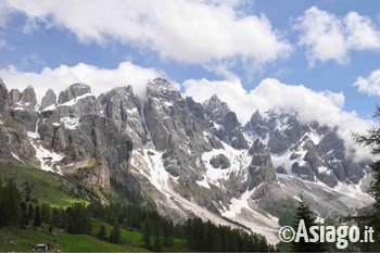
Pale di San Martino
Difficulty: Challenging
Equipment: we recommend the sticks (steep downhill, although without difficulty and always on the trail)
Height difference: 500 m 200 m uphill, downhill
Culmination point: 2217m, fork Venegia
Time: 5 hours
Type of tour: crossing
Transportation: cars
Start: passo Valles, 9 hours
Return: around 16 hours in Pian dei Casoni-Paneveggio
Maps: Tabacco map n° 22
Naturalistic-environmental Guide: Gianni Fridge
Achieved step Vallès (2031 m) climb through the red sandstone of Val Gardena and the Dolomites bituminous dark alternating with plaster casts of Bellerophon until you reach Fork Venegia (2217 m), the highest point on the route, set on limestone and on the marne the formation of Werfen, rich in marine fossils and ripple marks.
Affacciatisi so on the Val Venegia, we can admire the highest peaks of the Pale di San Martino: the Vezzana (3192 m) and the legendary Cimon della Pala (3184), separated from the Travignolo Gully with what remains of its glacier.
Descend, through beautiful pastures characterized by the presence of primula farinosa, meet the dolostone of the cliffs here reach and exceed 1200 m thick.
Reached the Campigol della Vezzana (1925 m), a real Alpine Garden at the foot of the Travignolo Glacier (from which the stream of the same name), we will stop to admire its beautiful bloom but also stubbornness with which larch and Swiss pine survive in a continuing struggle against avalanches and landslides.
We'll then downhill to malga Venegiotta, the watercourse crossing its riparian areas and some wetlands where they grow very rare species related to the Riverside saliceti (Salix mielichhoferi, s. Waldstein, s. nigricans, etc.) and the green area of glacial floods (Carex microglochin, c. bicolor, Juncus arcticus, Kobresia simpliciuscula, etc.).
You reach the malga (1824 m), and fed at his farm, we will continue to go down the wide Valley reaching finally parking Pian dei Casoni (1675 m).
Warning
To facilitate the recovery of cars at the end of the hike, the morning will bring a parking in advance of Pian dei Casoni.
Cost of the excursion: help Cost + insurance
Adults: 20€
Boys: €10
For more information contact the number
The guided tour is run by a guide included on the provincial list of Vicenza and theAssociazione Italiana hiking Guide Ambientali
RESERVATIONS REQUIRED BEFORE 18.00 the DAY BEFORE:
Phone: i send an e-mail. To contact us please click the buttons below.
NO reservation by SMS are not always read!
DRESS CODE:
Walking boots or hiking boots, long pants, anorak, Cap and sweatshirt, headlamp
Recommended Accessories:
Trekking poles, sunscreen, camera, fleece cover.
ABOUT US-HIGHLAND GUIDES
Us "Plateau" we are the first group of professional guides of the plateau. We are local guides who operate on the territory of the Altopiano dei Sette Comuni since 2008. Membership to the site by members of the group ensures an intimate knowledge of the proposals and a deeply respectful approach towards the environment and its history. Our guides are mountain professionals recognized and enrolled in the province of Vicenza; they propose to accompany busloads of people hiking and tours around the area, as required by regional law No. 33 of 04/11/2002 and according to the laws of the professional bodies of which fan part.
READING The DEGREE Of Difficulty:
EASY: The route takes place on forest roads, dirt roads or easy trails always well stated and without orientation problems in case of fog or bad weather. The slopes are within the 250-300 meters and the length of the route is included in three hours. It is a little long walks requiring a sports shoe, not necessarily the lightweight boot or boot.
EASY/MEDIUM: The route takes place on forest roads, dirt roads or easy trails always well marked. The slopes are within the 250-300 meters and the length of the route is included in 3-5 hours. It is a little long walks that require hiking shoe or boot.
Medium: The route exceeds three hours, is more complex, takes place on the trail with some challenging ascent or descent but surmountable without mountaineering equipment. The land can be disconnected or missing signals. The maximum gradient is still within 300 metres.
AVERAGE/CHALLENGING: The route exceeds three hours, is complex for the difference of up to 500 meters or for the length of walk up to 6 hours, takes place on the trail with some challenging ascent or descent but surmountable without mountaineering equipment. The land can be disconnected or missing signals.
Challenging: Are routes that require extended training, experience and physical strength on the part of those who follow them. You must know how to move with skill even in dangerous terrain: steep scree, steep slopes or dense Bush, tall and unreferenced, rock steps, lack of sources. The difficulty of the terrain and the distance from reference points require a total autonomy. Where indicated there may be a need to bring the following material to bivouac as the tent, bivouac sack, stove, food, requires training, energy and motivation.
All rights reserved.