Itineraries for excursions
Route Forte Corbin - Mount Cengio
Treschè Conca - Fort Corbin - Monte Cengio - Treschè Conca
PATH FEATURES
This easy ring itinerary,starting and arriving at Treschè Conca,takes the hiker to discover places of great historical interest,linked to the wartime events of the Great War: Fort Corbin and Mount Cengio.
Theroute to punta Corbin Fort is signposted and the fund is in good condition until the Fort, which has recently been renovated. Even in the rest of the route the trail is generally in good condition.
The route as a whole winds both on paved and dirt roads and, given the presence of tunnels to explore, it is advisable to keep a torchin your backpack.
ITINERARIO: Treschè Conca Excursion - Fort Corbin - Mount Cengio - Treschè Conca
Technical guidance
Degree of difficulty: easy
Difference: about 250m
Altitude-min: 1094m above sea level
Maximum altitude: 1354m above sea level
Length: 17km (round trip)
Walking time: about 6 hours A/R (visit to fort excluded)
Means: Walking or MTB
HOW TO GET TO THE STARTING POINT
Starting from Asiago,you reach the hamlet of Treschè Conca by taking the provincial road to Vicenza.
Once you arrive at the roundabout that leads to the center of Treschè Conca you hold the left and continue along Via Fondi,where at the small roundabout you hold the right and you follow the signs to the Fort Corbin, along Church Street for about 850m. The church is on the left.
Those who want to reach the church of Treschè Conca climbing from the plain,instead, from the exit of the highway of Piovene Rocchette will have to follow the Road Del Costo (Provincial Road 349) to the entrance of the village of Treschè Conca, where you will have to turn slightly left in Via Campiello and continue straight via Fondi to the small roundabout.
At the roundabout he will then have to turn left taking the second exit and, following the directions to Fort Corbin,continue along via Church until he reaches the church, which is on the left.
Car stopping point: parking near the Church of Treschè Conca.
ROUTE DESCRIPTION
From the parking lot of the church of Treschè Conca, you walk in the direction of Fort Corbin, passing in front of the village kindergarten.
Elf Fountain
The Church is the symbol of this Roanese hamlet and is famous for the presence of the evocative and scenic "fountain of the elves",which overlooks the mountains to the west of the Plateau.
After about 900 m at the junction of Malga Ronchetto/Val di Gevano, the right is held and we continue slightly uphill along the paved road, always following the signs for fort Corbin. Once you arrive at the junction for Malga Roccolo you have to keep your right and continue on the main road, following the signs written on the road surface.
Continuing along the road you can notice on the right a colored stone,which invites to visit the memorial stump of Augusto Giuliani,an irredentist Trentino soldier who fell very young to this place in 1916.
Nearby, a little hidden under the trees, there is a second tombstone in memory of another irredentist, the Trieste-American Carlo Stuparich,who also fell here during the Strafexpedition and then awarded the gold medal of valor.
After a short time you reach the place known as "the Pillars",where there is still one of the two pillars that delimited the access road to the historic Barracks of the Carabinieri Regi,of which today you can see only the ruins, and continue along the paved road for another 2 km.
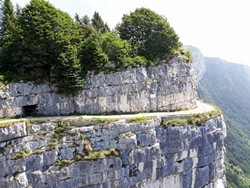
After walking the first 5km you arrive at the Fort of Punta Corbin,the largest of the great war fortresses present on the Plateau. The fort is currently a large open-air museum and is fully opento it, through ticket purchase. The visit lasts about 1 hour and at the fort you can enjoy a beautiful view of the underlying Val d'Astico, as well as stop for a refreshment before leaving.
With his backpack back, we are now heading towards Mount Cengio,travelling a little more than 2km down the road on the way.
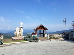
Following the directions on the asphalt, you then have to turn right along the road cemented forbidden to motorized vehicles and continue with a slight ups and downs to the Granite Square. Nestled in the greenery, this is where the visit of Mount Cengiobegins.
For those interested, shortly after leaving the fort behind, you can see an arrow placed on the right indicating the sculpture called "the wise", carved on the rock by a Vicentino sculptor in the late nineties. This work represents an old face and urges the passer-by to meditate,in a scenic place of rare beauty.
Once you reach the Square of the Greed,you have to move to behind the hut and climb the white street, along which you can make a stop at the votive church of the Greeders of Sardinia,and then continue to the Piazzale Pennella.
When you arrive at this square you can make a new stop to admire the surrounding panorama and read the tables, with some information about the events that occurred during the Great War. From here you can also quickly reach the monumental and scenic area on top of Mount Cengio,where a large cross and a stone altar sanction the sacredness of the area.
Back from Piazzale Pennella you can walk along the famous Grenadier,a path of 8 tunnels that winds on the slopes of the mountain overlooking the Vicentine plain.
The first section has 5 tunnels and after about 1km leads up to the vicinity of the Granite Square. This makes it clear that we are on our way back.
Once you arrive at the Greed Square you have to follow the CAI signs for Piazzale Prince of Piedmont,thus following the second part of the Greennese, about 1.5 km long, where you cross 3 other tunnels and you can observe a trench.
Once you arrive at the Piazzale Principe di Piedmont, where the Church of blood donorsis located, you have to follow the directions for Malga Roccolo.
Along this stretch of route that takes you back to Treschè Conca, you cross very extensive pastures, called "Prà of the pools",which offer hikers a spectacular 180-degree panorama that ranges from Tonezza del Cimone – in the west – to Asiago.
After Malga Roccolo, you go down and come down along the first asphalt section of the route at the beginning of the hike, a sign that the route has now come to an end.
© Asiago.it RESERVED REPRODUCTION
PHOTO GALLERY OF THE ITINERARIO TRESCHè CONCA - FORTE CORBIN - MONTE CENGIO - TRESCHè CONCA
All rights reserved. We accept no responsibility in the event of damage to persons and things that occurred along this route.


