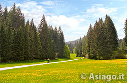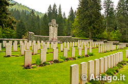
Near the cemeteries of Val Magnaboschi
Itinerary For Mountain Bike (MTB) Tresche Conca – Val Magnaboschi
Itinerary for Mountain Bike (MTB) easy to travel, except for the stretch of very unpaved climb that cuts through the ski slopes of Cesuna, allows you to go and visit the English cemetery and the Italian-Austrian one of Val Magnaboschi. There is also a passage near the trenches of the area of Mount Lemèrle, a place of fierce fighting.
ITINERARY (MTB): Tresche Conca – Val Magnaboschi
Technical indications
Length: 12,5 Km
Difference in altitude: 250 mt.
Maximum height: 1170 mt
Difficulties: EASY
Walking time: 2 hours
HOW TO GET TO THE STARTING POINT
The mountain bike route starts from the headquarters of the ProLoco of Treschè Conca, which partly occupies the old train station that, until 1955, took passengers from the plain to the Asiago plateau. After about 100 meters from the starting point, go down using the underpass that crosses the main road and continue towards the football field, taking the road that leads to "Pannocchio".
ITINERARY DESCRIPTION
This stretch of climb, although it has a pronounced slope, is paved and of short development, so it is easily overcome with the mountain bike even by those who do not have great skills. Arrived at a hill where the view opens towards the Plateau of the 7 Municipalities, descend in the direction of the hamlet of Cesuna. Without getting too caught up in the pleasure of the descent, pay attention to the paved road that goes up parallel to the right where, at the junction, there is a capital with a cross. Going up this road, near a bend, there is a fence with animals. After a few hundred meters, keep left at a monument dedicated to the fallen.

English Cemetery Val Magnaboschi
Here begins the most challenging point of the itinerary because, at times, the road has pronounced slopes, with a sometimes uneven terrain. The road crosses the ski slopes, including the ski lift line that leads, in winter, skiers to Monte Zovetto.
Be careful not to pedal off the track, because you may encounter barbed wire that serves to delimit the properties and grazing areas. Crossing the asphalt of the road that leads to Monte Zovetto, turn left and go down for a few hundred meters to the church of St. Anthony.
In this area you can visit two adjacent cemeteries: the English and the Italian-Austrian. In fact, the area, at the time of the First World War, was bitterly disputed during the Strafexpedition, when the Italian departments (brg. Forlì and Liguria) definitively managed to stop the imperial advance.

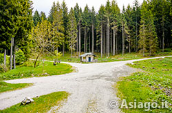
Boscon hut, intersection of the 5 roads
From the church, take the dirt road that goes up in the direction of the Rifugio Bar Alpino, follow it for about 200 meters and abandon it immediately after, keeping to the left in the direction of the area of the step of Mount Lèmerle.
The road arrives after a few kilometers at the junction of the Boscon hut, where you can make a stop from the bicycle or find shelter in case of bad weather.
From the junction take the flat road to the left that leads, after about 4 km, towards the hamlet of Cesuna.
In Cesuna you reach the square of the old station, cross it and direct the mountain bike in the direction of the road that goes up to the Baita Jok.
In collaboration with Altopianobike
ROUTE MAP
PHOTO GALLERY OF THE ITINERARY TRESCHE CONCA – VAL MAGNABOSCHI
All rights reserved. We accept no responsibility in the event of damage to persons and things that occurred along this route.