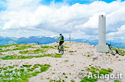
Cima Ortigara and its severed column "not to forget"
Itinerary For Mountain Bike (MTB) Asiago – Monte Ortigara
Mountain Bike (MTB) route on Mount Ortigara, symbol of the Great War, a place where over 12,000 Italian and Austro-Hungarian soldiers lost their lives in June 1915. This excursion of high historical value, even if it presents difficulties and is not suitable for novice cyclists, deserves to be done at least once.... not to forget..
ITINERARY (MTB): Asiago – Monte Ortigara
Technical indications
Length: 46 Km
Difference in altitude (descent Campi Lussi): 1500 mt.
Difference in altitude (descent Piazzale Lozze):1680 mt.
Maximum height: 2105 mt
Difficulties: DIFFICULT
Walking time: 4 hours 30
HOW TO GET TO THE STARTING POINT
Approach climbs towards the Ortigara there are several but only one is almost completely cyclable in its final part, of course with good training and good technique.
There remains the possibility to cover the most difficult stretches with the Mountain Bike by hand.
The proposed itinerary is the one starting from the Asiago Ice Stadium. Leaving the car park, continue towards Camporovere crossing the intersection with the main road that comes from Canove. Follow the asphalt to the hamlet of Camporovere, admiring along the road the meadows and promontories of the Plateau.
ITINERARY DESCRIPTION
Once in Camporovere, continue along the asphalt towards Trento for 4 km until you meet the junction for Val Galmarara on the right. Here the road becomes unpaved and climbs slightly until you reach the junction "Basa Senocio". At the fork turn right and go up for 4 hairpin bends. The slope and the bottom in this stretch become a bit insidious up to Malga Galmararetta, reached after about 3.5 km.
From the malga the road paves a bit to Malga Galmarara (visible on the left), digression from the Mountain Bike recommended before facing the most challenging sections of the itinerary. Not wanting to opt for the malga, the itinerary continues straight leaving out the side streets.
From this point the road becomes more challenging, climbing with hairpin bends and straights that line the mountain to the Conrad junction, where you have to keep to the left. From the junction, take another 600 meters until you reach the Bivio Italia, the main door towards the last stretch of the climb towards the Ortigara.

On the left the hut Cuvolin
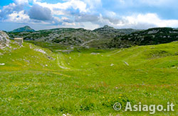
Here the landscape begins to become lunar: devoid of vegetation and jagged with many rocks and little grass. Continuing to follow the direction towards the top, you pass first near the Baito Bordignon and then near the Baito Cuvolin. Walking along the road, which passes through ups and downs with rock walls next to it, is very suggestive, . Shortly before arriving at the area called Campigoletti, leave the dirt road and take the sentiero n. 839 which, in the first meters and even later in some sections, forces you to get off the MTB due to strong disconnections.
From this point to the top, the route turns out to be quite challenging for width and for the presence of rocks and steps. Managed to overcome this stretch lasting about 15-20 minutes, you arrive at the bell of Mount Ortigara and, after a hundred meters, on the top where you can admire the severed column placed in memory of the fallen.
Leaving the Mountain Bike, you can go on foot to visit the Austrian Cippo and the trench area. Do not forget also the frame of the peaks of the surrounding mountains, as well as the almost sheer jump towards the Valsugana located 1700 meters below. After the ritual photos it's time to think about the descent.
THE DIFFERENT ROADS TO RETURN
The recommended routes for the return are three, with the premise that for all there are more or less long stretches in which to carry the MTB by hand.
The first, and less demanding, is to go down the road of the outward journey perhaps opting for some variant to be evaluated from time to time given the multiplicity of intertwining roads available;

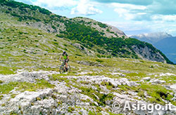
Challenging stretches within walking distance of the summit
DESCENT TO PIAZZALE LOZZE
The second is the intermediate one that descends towards the Church of Lozze. In this case from the top you descend in a south-east direction using the path n ° 840-841 that passes through the Ortigara and Cecchin huts. Keep in mind that in this stretch, until you reach the Church of Lozze, you will have to carry the Mountain Bike by hand for almost the entire journey, as the path hardly allows you to pedal and / or descend safely.
From the Church of Lozze, you can get on the MTB and get off more easily until you reach Piazzale delle Lozze. Once at the square, take the dirt road on the right that leads to the Malga Moline Refuge. From the refuge, where during the opening periods it is advisable to make a stop, go down the dirt road again to Piazza delle Saline where you will opt to turn right towards Monte Forno.
Right at Monte Forno, after about 2.1 km from the junction in a curve to the right, there is a grassy road on the left that descends in the direction of Baito Terre More. To reach the hut, there are two small depressions to overcome with as many challenging climbs but only a few hundred meters long.
After these small bumps the road begins to descend with a very pleasant trend. At some point, at a meadow, keep right for a path that goes into the woods. The path becomes a beautiful single track that leads to Casera Busette (path No. 836). Cross the road towards the casera turn right towards a junction with 4 roads.
Go straight towards the Val di Nos with a very long (6.5 Km) and fast descent that, in a short time, leads to Asiago and more precisely to the Colle del Gastagh area. From here you will find the main road that leads to the center of the village and the starting point of the itinerary.

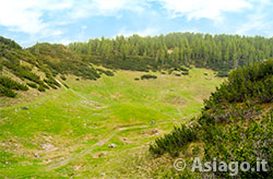
The small valley where the Campi Lussi bivouac is located
DESCENT TO BIVOUAC CAMPI LUSSI
The third descent is different only in the initial part and more precisely: from the bell look towards the south-east the downhill path towards a depression (path No. 839). Circumvented this depression, continue the descent in a south-east direction towards Bivouac Campi Lussi. This stretch of road that leads to the small valley where the bivouac is located, is even more challenging than the other descent options and with the obligation, even here in many sections, to bring the Mountain Bike (MTB) by hand.
Once you reach the depression, reach the bivouac riding your MTB, pass it, and continue for a steep climb that leads to a path even less practicable than the previous one. Here you have to push the Mountain Bike more decisively and in a stretch lasting 5-10 minutes, you have to carry the MTB on your shoulder to overcome some steps uphill.
After this stretch the path descends towards the road that leads to Monte Forno. From here the descent is common to the one to Piazzale Lozze mentioned above.
In collaboration with Altopianobike
MAP ROUTE #1 (DESCENT TO PIAZZALE LOZZE)
ROUTE MAP #2 (DESCENT FOR BIVOUAC CAMPI LUSSI)
PHOTO GALLERY OF THE ASIAGO ITINERARY – MONTE ORTIGARA
All rights reserved. We accept no responsibility in the event of damage to persons and things that occurred along this route.