Tuesday 14/8/2018 at 08:45
Guided excursions

Guided excursion in the places of the great war with Asiago 7 Comuni Plateau and Guides-"Strong Lisser with inner tour" with Guide Altopiano di Asiago and 7 Municipalities
"THE BIG STORY OF THE PLATEAU"
After the Rout of Caporetto "and because of the failure of the northern part of our lines on the Tagliamento River and the passage of austro-German troops, the Italian high command ordered the withdrawal on the Piave and the Grappa. On 9 November 1917 Asiago falls into Austrian 10 hand tap to Gallium. Fast jump all Italian strongholds.
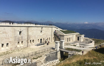
To the East it comes back to fight on defenses in 1916 during the Strafexpedition. The Austrians now have descended from their front line on the Ortigara, popping up all over the plateau, past the plain of Marcesina, upstream Lisser occupy positions of Summit forcing the alpini battalions monte Baldo and Vestone to retreat towards Malga Lora North of Foza. The Fort was built by the Italian army at an altitude of 1630 Lisser meters above the town of Enego between 1912 and 1914 to bar access to Austrian troops to Eastern Valsugana.
Already heavily hit by bullets from 30.5 cm in June 1916 during the spring offensive, on 13 November 1917 will fall permanently until the end of the first world war in the hands of Austria.
EXCURSION PROGRAM:
Departure scheduled at 8.45 from the Bar at the station near the entrance of the square the ice stadium of Asiago;
Hiking time: 5 hours guided tour except lunch time possible
Fix (look at the description at the bottom of the page): average if wet the trail
Elevation difference: 350 m
Possibility of stopping for lunch or a Lot
Displacement: with your car
COST OF THE TOUR INCLUDES ENTRANCE TO THE FORT WITH GUIDED TOUR
Adults: €18.00 includes entry and guided tour inside the Fort by the Historian Malatesta
Children under 15 years: €7.00 includes entry and guided tour inside the Fort by the Historian Malatesta
Guide: Anna Saddle -historical and Environmental nature Guide Companion medium Mountain College Guides of the Veneto
RESERVATIONS REQUIRED BEFORE 18.00 the DAY BEFORE: (in term of places entries will be closed)
Contact us -
DRESS CODE:
Long trousers, Mountain boots, anorak, sweatshirt or fleece, hat, water, suitable attire for a hike in the mountains.
RECOMMENDED ACCESSORIES:
Sunglasses, sunscreen, trekking poles.
ABOUT US-HIGHLAND GUIDES
We "Guides Plateau" we are the first group of professional guides of the plateau. We are local guides who operate on the territory of the Altopiano dei Sette Comuni since 2008. Membership to the site by members of the group ensures an intimate knowledge of the proposals and a deeply respectful approach towards the environment and its history. Our guides are mountain professionals recognized and enrolled in the province of Vicenza; they propose to accompany busloads of people hiking and tours around the area, as required by regional law No. 33 of 04/11/2002 and according to the laws of the professional bodies of which fan part.
READING THE DEGREE OF DIFFICULTY:
EASY: the route takes place on forest roads, dirt roads or easy trails always well stated and without orientation problems in case of fog or bad weather. The slopes are within the 250-300 meters and the length of the route is included in three hours. It is a little long walks requiring a sports shoe, not necessarily the lightweight boot or boot.
Easy/medium: the route takes place on forest roads, dirt roads or easy trails always well marked. The slopes are within the 250-300 meters and the length of the route is included in 3-5 hours. It is a little long walks that require hiking shoe or boot.
Medium: the route exceeds three hours, is more complex, takes place on the trail with some challenging ascent or descent but surmountable without mountaineering equipment. The land can be disconnected or missing signals. The maximum gradient is still within 300 metres.
Average/challenging: the itinerary exceeds three hours, is complex for the difference of up to 500 meters or for the length of walk up to 6 hours, takes place on the trail with some challenging ascent or descent but surmountable without the support of mountaineering equipment. The land can be disconnected or missing signals.
CHALLENGING routes that require training are experienced and physical strength on the part of those who follow them. You must know how to move with skill even in dangerous terrain: steep scree, steep slopes or dense Bush, tall and unreferenced, rock steps, lack of sources. The difficulty of the terrain and the distance from reference points require a total autonomy. Where indicated there may be a need to bring the following material to bivouac as the tent, bivouac sack, stove, food, requires training, energy and motivation.
All rights reserved.