Itineraries for excursions
Ring route for Malga Pian di Granezza and Monte Mazze
ITINERARIO: The Path of the Partisans
Technical guidance
Degree of difficulty: Easy - Medium
Positive difference: 170m
Maximum altitude: 1420m above sea level
Length: 6.4km
Walking time: 3.5h (with stop in Malaga)
Means: walking
INTRODUCTION TO THE ITINERARY
The itinerary is located entirely within the municipality of Lusiana-Conco especially in the area of Mount Horn. Interesting tour both from a landscape and historical point of view for the still visible signs of the former artifacts dating back to the First World War and for some events related to the Second World War. it is a path suitable for families and people who want to spend a day immersed in an environment rich in nature and history.
HOW TO GET TO THE STARTING POINT
Starting by car from the parking lot that leads to the square of Lusiana you proceed along the SP 94 towards Asiago and after 20 meters you turn on the SP 69 always maintaining the direction to the city of Asiago. We proceed on the same road for about 6.5 km until you reach the junction with indication for Mount Horn - Granezza. Turn left and keep the road taken for another 5 km until you get to the large parking lot of the Mount Horn Bay. From here, we walk to the Malga Pian di Granezza, the starting point of the itinerary.
PATH THE PATH OF THE PARTISANS
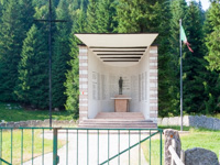
After parking the car, possibly in the northern part of the Plain of Granezza,you can reach by walking along the road the Sacello dedicated to the Partisans who fell for the liberation of Italy from Nazi-fascist rule in 1943-45. The monument is located where the bright meadows of Granezza end to the north and the road of barenthal plunges into what is still known as"Black Bosco":a vast forest that being formed mainly by evergreen conifers,such as the white and red firtrees, generates an environment in which the rays of the Sun do not reach the ground, leaving it in a fresh penumbra. it is precisely the distance of this place from the population centers of the Plateau, during the Resistance controlled by the Germans and the republicans, that had made him choose by the Partisans to place their bases and the Granezza Plain had become one of the reference points for the parachuted aviolancies of materials, weapons and men that the Anglo-Americans carried out in order to help the insurgents. It is therefore easy to understand why, in the course of the round-ups put in place by the Nazi-fascists during 1944,so high was the price in human lives paid on these mountains by the Resistant. Hence the idea of dedicating to them a monument on the summit of Monte Horn,the Sacello in Granezza and the path that, at least in part, we will walk.
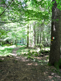
At the entrance to the fence that borders the meadows, just in front of the Sacello,you will find the tables of the path of the Italian Alpine Club No.888 or"Sent. of the Partisans" who will lead us, with its red and white markers on stones and trees, to Mount Raitertal and beyond. Crossing the lawn,holding to our right the stone slab fence of the monument,we reach the edge of the forest at an additional table that indicates the beginning of the mule track at a valley that begins to rise through a track shaded by the vegetation until you find two yellow arrows with the tricolor,one indicates the continuation of the path while the other gives the direction of the first of the tombstones that remind them of the first of the tombstones. Just past you pass a lattice thanks to a gate formed by two bars and you come near another memorial plaque. Continuing to walk in the woods with some ups and downs you will reach the top of Mount Raitertal,marked by a votive cross and an altar; on the left a table with the tricolor indicates where the "kitchens" of the partisan departments allocated here were placed.
By giving your back to the altar you continue the path, always following the white and red signposts of the CAI,slightly downhill and turning almost immediately to the left. More or less at altitude and paying attention to the CAI markers and the yellow arrow tables with the tricolor proceeds in the west direction until you reach the headstone of another fallen and, shortly after, the "hunger pit" that reminds us how, although there are the sumptuous kitchens, often the pots were filled mainly with ... Water. At this point it is necessary to pay close attention because about a hundred meters beyond the Pozzetto we have to abandon the path CAI and its signposts, which with a sharp sharp turn to the right descend to the Rogabisa,to continue along the left lane in the direction "Porco peak", as indicated on a boulder placed next to the mule in front of us. It continues by always keeping the left in the two intersections with forest roads that follow until you emerge from the woods at a clearing with a pool of watering with an area equipped for picnics and illustrative tables placed by the City of Calvene: the Pool of Xomo. We then descend along the forest road until it is grafted onto another road, this time military and stony bottom,which takes us to the left to skirt the clearing of Prà Peloso and then the station of the old ski lift of Monte Mazze. Just beyond you arrive on the meadows of Malga Mazze Superior and, in short, in Bocchetta Granezza. Passing in front of the Monte Horn Refuge you follow to the north the paved road just to the side of which we find first the monument to the Italian forced workers of the "Speer Organization", then the headstone dedicated to Lieutenant Colonel Knox and immediately after one of the five British cemeteries of the Plateau. Continuing along the meadows on which the brown-alpines of Malaga Campo di Granezzagraze, in short you reach the structure where to this day their milk is transformed into butter, cheese and cottage cheese. The residual serum of the dairy is used as a food for pigs that have always been transformed into salami, suppressed and bellies,enrich the products of the malghe. After taking advantage of this well of God to restore the energies spent, at most in a few minutes you are in the cars.
© Asiago.it RESERVED REPRODUCTION
PHOTO GALLERY OF THE ROUTE THE PATH OF THE PARTISANS
All rights reserved. We accept no responsibility in the event of damage to persons and things that occurred along this route.


