Particular rocks
Itineraries for excursions and walks: Excursion to the Castelloni di San Marco
The itinerary leads to the discovery of one of the most particular places of the Plateau of the 7 Municipalities. Of medium difficulty, it is suitable for visitors who want to spend a day inside the characteristic "rock labyrinth" that makes this location unique in the Plateau.
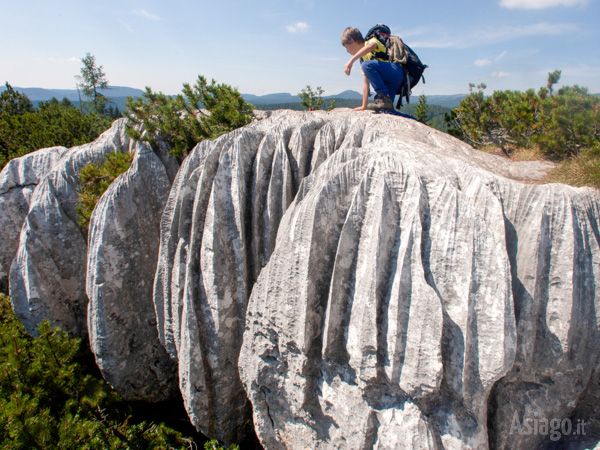
The interest is geological for the rock formations of the Lower Pleistocene; of faunal and floristic type due to the presence of protected and particular animals and vegetation ; and historical for the presence of galleries, stairs and walkways dating back to the First World War during the Stafexpedition.
ITINERARY: Castelloni di San Marco
Technical indications
Degree of difficulty: medium-demanding
Altitude Bivio Tiffgruba (starting point): 1565 m
Altitude Malga Fossetta (alternative starting point): 1666 m
Castelloni di San Marco altitude (arrival point): 1830 m
Difference in altitude: 267 m
Means: on foot
VARIANT 1 (complete itinerary)
Departure: Tiffgruba junction (along the road that leads from Campomulo to Ortigara - reachable by dirt / asphalt / cemented road) in fair condition (always with caution)
Distance: 8,7 km
Walking time: 5/6 hours with tourist pace, including the path in the labyrinth
VARIANT 2 (reduced itinerary)
Departure: Malga Fossetta (reachable only by car 4x4 with caution - not recommended for normal means)
Length: 6.7 km starting from Malga Fossetta (including labyrinth)
Walking time: 5/6 hours with tourist pace, including the path in the labyrinth
It is recommended to read the warnings of the itinerary
HOW TO REACH THE STARTING POINT OF THE ROUTE
Starting by car from the square of the Asiago Ice Stadium, proceed on the SP 76 in the direction of Gallium. Once in Gallium and past the center, follow the signs towards Melette-Campomulo. Continuing along the main road for about 6.5 km, you reach and pass the Campomulo Refuge located on the left and proceed for 1.5 km towards the Campomuletto Refuge; from here the road begins to be unpaved.
For this itinerary two starting points are possible:
Junction TiffGruba (complete itinerary)
Reachable by car (with a little caution) along the road for about 7.4 km (from Campomuletto).
Starting from here the length will be 8.7km (including the path in the labyrinth), with the first stage Malga Fossetta at 1km and with a travel time with a tourist pace of about 5/6 hours.
Malga Fossetta (reduced itinerary)
From Campomuletto, proceed straight on keeping the main carriageway for 7.5 km until you reach the junction towards Malga Fossetta, the second possible departure of the excursion. The estimated time from Asiago to Malga Fossetta is 40 minutes. We recommend the departure from Malga Fossetta only if you are equipped with a 4x4 car as the dirt road from the Tiffgruba junction to Malga Fossetta is not in good condition. Starting from Malga Fossetta the walking route is shortened by about 2km, for a total of 6.7km (including the tour in the labyrinth) with a travel time, with a tourist pace, of about 4/4.5 hours.

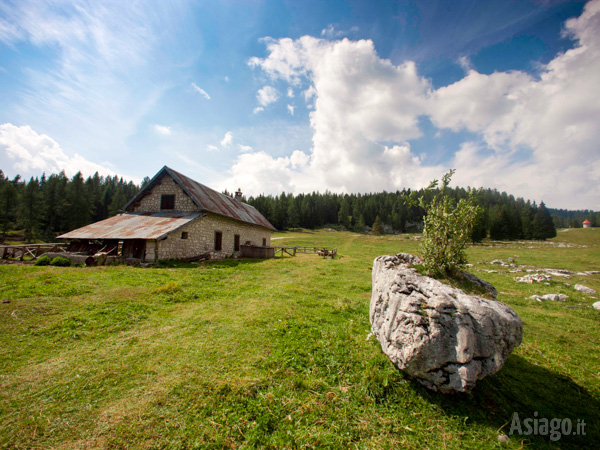
Malga Fossetta
ROUTE TO THE CASTLES OF SAN MARCO
If you start from the Tiffgruba junction, follow on foot the signs of the CAI path 845 towards Malga Fossetta (altitude 1666m), which will be reached after about 1 km of walking with a strong difference in height.
From here the path continues along the path n ° 845, leaving the hut on the left, you proceed along the pasture until you reach the mixed forest of firs, larch and fragrant mountain pine.
The rich nature of this area offers a spectacular arboreal vegetation and a rich herbaceous vegetation formed by some particularly valuable specimens such as the martagone lily (Lilium martagon L.), the gentians (Gentiana spp.), the hairy rhododentro (Rhododendron hirsutum) that accompanies the dwarf juniper (Juniperus nana), the blueberries (Vaccinium myrtillus) and the heather (Erica carnea) that creates bearings first green of the leaves and then pink of its flowers.
Continuing along the well-marked path, after about 15 minutes of walking you reach a junction and keep the path on the right. In this area you begin to notice the spectacular karst formation that characterizes the entire castelloni area.
The path begins to climb and the footprints and signs left by the animals are not long in coming, in fact along the way are visible centuries-old fir trees now dead due to the numerous insects present in the wood and which in turn have helped to feed the woodpeckers, inhabitants of this area.
Walking along the path in silence, other forest animals are visible such as the fox (Vulpes vulpes), the roe deer (Capreolus capreolus), the marten (Martes foina) and passerines such as the tufted (Lophophanes cristatus) and the blackberry (Parus ater).
After a short time you arrive at another junction called the Anello dei Castelloni and take the path on the right. For a short distance the soil changes and turns into a terrain of karst rock, the furrowed fields, that is, rocky surfaces with sometimes deep coves that certainly require the attention of those who cross them.
THE ARRIVAL POINT: THE CASTLES OF SAN MARCO
After finding the safe ground, you arrive near a real chasm: the Pozzo dei Castelloni, a karst cave about twenty meters deep. Passed, you climb up to a crack in the rock: the beginning of the Labyrinth of the Castelloni di San Marco.

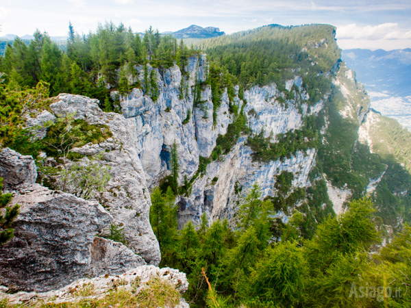
Promontory with wide panorama
The amazement of the route will surely be great, shaped rocks, cracks, rock passages, tunnels, real canyons, will be the spectacle of those who visit them.
Among the various coves and rocks the landscape will range to the north with the Valsugana and the Lagorai, but the rest of the plateau will also be clearly visible as the northern area of Cima Caldiera, Cima Ortigara, Cima Undici, Cima Dodici and Portule, the central basin up to Asiago and the cold plain of Marcesina.
At the end of the labyrinth, you find yourself immersed in the green of the vegetation and now proceed towards the opposite side to the one from which you climbed. You then return to the junction of the Anello dei Castelloni di San Marco and from here you take exactly the same path as the outward journey, until you return to Malga Fossetta or the Tiffgruba junction.
WARNINGS:
It is a challenging excursion for length and altitude difference, not a picnic, to be faced with due attention and equipment (minimum requirements for hiking shoes and water).
It is advisable to pay attention in the path, which in some sections, especially of the labyrinth, presents dangerous passages if not approached with due attention.
It is recommended to check the weather before trying your hand in order to cover it in good weather and dry ground (also pay attention to summer thunderstorms), as in some places the path if wet can become particularly slippery.
Also be careful to calculate the travel time well to be able to return before it gets dark, keeping a good margin of safety.
The itinerary can only be traveled on foot, impossible to travel with strollers or MTB / Ebike.
PHOTO GALLERY OF THE ITINERARY AT THE CASTELLONI DI SAN MARCO
Photo by Stefano Maruzzo