Itineraries for excursions

Mount Corno
Itineraries for excursions and walks: Excursion to Monte Corno
In the southern partof the Asiago Plateau is the village of Lusiana (750 m above.m sea level) which has a territory crossed by wide valleys with streams and streams at the lowest altitudes and typical Alpine environments at the highest altitudes. To the north of the town we find Monte Corno (1383 m above.m sea level) where together with the naturalistic landscape you can observe both centuries-old anthropogenic activities related to the pasture and testimonies of the Great War such as military cemeteries and entrenchments. The path to the top winds through woods, meadows and particular karst formations called "rock towns".
The latter consist of a spectacular excavation by the water that percolates on the rocks of Rosso Ammonitico creating corridors between the large boulders. On the southern side of Monte Corno you can visit the Botanical Alpine Garden (1350 m.m above sea level - entrance for a fee) which is located on a stony-rocky promontory between two grazing areas. The site is home to the main vegetation environmentsof the Asiago Plateau in which there are herbaceous, shrubby and tree species belonging to the mountain subalpine flora.
The route is ideal for those who want to combine an itinerary of historical value,without neglecting the many naturalistic, landscape, anthropogenic and geological beauties present in the area. The hike is considered easy and is only walkable.
ITINERARY: Mount Corno
Technical indications
Degree of difficulty: easy
Height difference: 123 m
Altitude-min: 1260 m above sea level
Maximum altitude :1,383 m above sea level
Length: 8 km
Walking time: 2 hours
Means: on foot
HOW TO GET TO THE STARTING POINT OF THE ROUTE
There are two access routes open to the public that allow you to reach the beginning of the itinerary. From Lusiana you go up in the direction of Asiago through the provincial road n.69 for about two km up to the junction that leads to Monte Corno (the road is paved). Take this road and continue until you reach Rifugio Monte Corno where you can park. From Asiago you take the road that leads to Bassano del Grappa (sp 72), after passing the Hospital of Asiago on the right there is a junction that leads to Granezza,take this road that is at times unpaved and sometimes paved, until you get to the Monte Corno Hut where you can park. From the parking lot of the Monte Corno Hut you will walk along the paved road that leads to the Granezza Hut,after about twenty meters on the right you can see the English cemetery where the route begins.

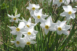
Daffodils on the trail
ROUTE TO MONTE CORNO
The path is marked by thesymbol of ammonite (drawn in red on rocks and trees) characteristic fossil in the shape of a spiral that is found profusely in the rocks of the place.
The excursion begins near the English cemetery of Granezza,inthe Asiago Plateau,where 142 British soldiers are buried including Edward Harold Brittain brother of the English writer Vera Brittain.
Continuing you head north, first following the limit of the pasture of the Piana di Granezza,then going up towards the mixed beech and fir forest. Soon along the path you can identify the first trenches and the forest becomes denser for the gradual greater presence of spruce. This leads to the complex, recently restored trenchsystem, which was built as a second line of defence after Strafexpedition in 1916. Thanks to the Zovetto-Lemerle-Kaberlaba-Ekar front, these positions were not directly involved in the war and therefore well preserved. As you continue you enter an even denser forest where next to the spruce and beech we find some white fir trees.
THE FINISH LINE: MOUNT CORNO

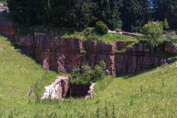
Trench in the Rock
Now the route coincides withan ancient street frequented by shepherds that leads to a floor with a single-species spruce forest. You reach the top of Monte Corno (1383 m above sea .m.) where you can visit the "city of rock"; along the rocky labyrinth you can also see two military posts carved in rock. In this place there are tables with benches for those who want to stop for a snack.
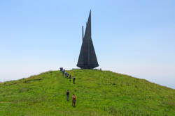
At the exit of the "City of Rock" on the right you can see a recently abandoned quarry; the path continues downhill to the east to the valley of Granezza di Gallio; going up the valley you can observe a fence of "laste" or "stoan platten" that served for the stop of the herds. This is how you reach Malga Monte Corno and the Monument to the Fallen in memory of the partisan fighting that took place during the Second World War. From this point you have a splendid panoramic view of the Venetian plain. Going down from the pasture you arrive at the Alpine Botanical Garden and return to the Monte Corno Hut.
PHOTO GALLERY OF THE ITINERARY TO MOUNT CORNO
All rights reserved. We accept no responsibility in the event of damage to persons and things that occurred along this route.