Itineraries for excursions

Malaga Fiaretta
Itineraries for excursions and walks: From Campomulo to Malga Fiaretta
FEATURES OF THE TRAIL
Asphalt road to Campomulo; then dirt in excellent condition, up to the intersection indicated by the Cai and the table that reads: "Monument to Pope John II"; so at times rough, sometimes with a good bottom. From the aforementioned intersection, to return to the base, a loop path is made: the path is presented in some places stony and rough, until the beginning of the lawn that descends to the parking lot of Campomulo.
ITINERARIO: From Campomulo to Malga Fiaretta
Technical guidance
Degree of Difficulty: Easy
Difference: 117 meters (from 1530 Campomulo to 1647 of Malaga Fiaretta)
Min altitude: 1,530m above sea level
Max Altitude: 1,647m above sea level
Length: 5.5 Km (round trip)
Walking time: about 2h (tourist gait)
Means: walking - mountain bike - horse
HOW TO GET TO THE STARTING POINT
Arriving from Asiago, follow the directions to Gallio (3 km away) until you get to the roundabout just before the country, where you have to proceed straight by taking the second exit. After 600 meters, past the center of Gallio, turn left following the signs to Marcesina, Melette, Campomulo and continue along the road for 6.5 kilometers.
Car stop point: Campomulo.
Arrival point: Malga Fiaretta and Alpine fountain.
DESCRIPTION OF THE ROUTE TO MALAGA
The Campomulo/Malga Fiaretta itinerary is, among the short ones, one of the most pleasant and varied landscape. From the aesthetic pleasantness of the Rifugio Malga Moline, to the comfortable parking lot, to the series of well-marked paths and inserted in downslivi full of flowers and lush woods.
As soon as you climb altitude, here are glimpses of the peaks of the ridge that from the Portule, Field of White Horn, Green Horn, Peak X, Cima XI,range up to Cima XII.... A curiosity: the 3 peaks of the same name, bear the name of an hour in the morning, so agreed by the shepherds that - not possessing clocks - they would meet with the flocks when the sun was at the zenith on top of their respective peaks... The whole Alpine chain bears peaks with the same names, indicating that wisdom and customs belonged to everyone: mountaineers, shepherds, peasants.
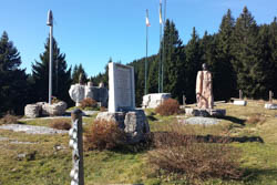
The attack of the path with prohibition of transit, next to the parking lot, is easy and allows you to quickly get to the intersection that leads to the left to the monument erected in honor of Pope John Paul II,for a visit to the Plateau. Just after thepope's altar we continue straight for 300/400 meters, we arrive at a spectacular place, theMilitary Observatory of the Great War,from which you can see the panorama with much of the Plateau of the7 municipalities.

Pope John Paul II
You leave the monument of the Pope to the left and continue uphill rights, where you meet the first signal of the Cai, which indicates the malghe Fiaretta and Fiara. In fact it is a crossroads: take the path to the right (while the path that is lost in the middle of the woods downhill will form the ring that will allow a quick re-entry).
The trail becomes more difficult here, but the variety and triumph of the vegetation all around it, distracts from fatigue. To the right remains of dry walls, certainly barracks of the First World War. Signs of "military mule" (yellow stripe) are detected, coinciding with the CAI signage (white/red), signs that have been traced indifferently on stones, trees, walls and serve as a natural guide to the walker. Both to the right and to the left of the path, we can see trenches, now covered with vegetation and semi-collapsed, but still there, mute witnesses of painful times. Many sections of the bottom are in "white", white stone, which elsewhere is known as majolica: one of the basic materials, for the production of pottery.
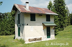
After the disconnection, you quickly arrive at the pool of pastures,an integral part of Malga Fiaretta now in disuse, but of great utility to wild animals, as evidenced by the trampling all around. A short ascent and here it is Malaga Fiaretta,divided into three buildings,a small ancient village perfectly maintained, including all the elements of the so-called"Malga complex": the farmhouse where cheese was made, shelter for animals (including the pigslaia) and the house of the two-story Malghese, which proudly bears the symbolic name of"Malga of Dreams". There is also a picnic bench,but the lawn certainly entices more.
Wherever you go for huts, the combination of these 3 elements is like the ancient one, even in those still in operation, in addition to the alpine pool and pasture. The three buildings of Fiaretta, have been rearranged for private use and it is good, because they are well maintained. A wooden crosshas also been planted. Sitting on the steps of the house, makes you take a step back in time and if you close your eyes, it seems to feel a vague bleed... suggestions of imagination! It is a beautiful place, full of charm, evocative of the proud past, where you would really want to stay a few days. But the surprises aren't over...
You take up the uphill path and immediately you find yourself inside a grassy esplantating, surrounded by pines: it was the ancient pasture, a limited space, in fact, but commensurate with the number of herdings. Among the pines, a wooden cross in memory of the fallen soldiers and behind, a long trench that outlines the ridge, from which to look out to see the peaks in front. At the bottom of the clearing, the grassy path leads straight to the fountain,which was used for home use: for quenching, for washing, for washing clothes, for cooking and making cheese.
It was renovated by the alps a few years ago and is therefore decorated with a mosaic alpine hat! Thedrinking water is still there: a perennial thread that for the farm yesterday was life and for the traveler is today a reason for rest and refreshment. From the fountain, the trail continues to Malga Fiara and below to Monte Forno, Monte Chiesa and Ortigara: all places that bear engraved the mark of what was one of the bloodiest and craziest wars of humanity. (The cemeteries of both sides, including allies, were scattered throughout the territory, while since 1935, almost all the bodies - as many as 55,000 - have been collected in the Leiten Shrine in Asiago, to the beginning of memory.)

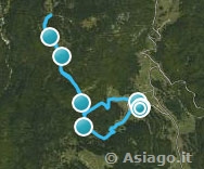
Campomulo Malga Fiaretta Itinerary
It's time to come back:... fountain, clearing, descent, Malga Fiaretta, puzza, ascent, neckline, drilling... and down the bumpy path on the left, in the middle of a thick forest of hazelnuts, beech and fir trees. Everywhere signs of military mule,in yellow, impossible to make a mistake, despite being a path not marked by the CAI. After about 700 meters. a forest signal painted on the rock, indicates a new crossroads. But now, the indications are no longer needed, because it opens in front of the eyes the conca in which the Campomulo shelter is lying. Seeing your car from above... and almost with relief, tossing himself down the grassy slope. And even for today the adventure is over!
Beppa Rigoni Scit

All rights reserved. We accept no responsibility in the event of damage to persons and things that occurred along this route.