Itineraries for excursions

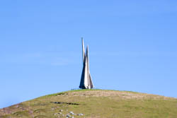
Monument to the Unknown Fallen on Mount Corno
Excursion itinerary from Osteria Fontanella to Monte Corno - Southern Ridge - Asiago Plateau
INTRODUCTION TO THE ITINERARY
This pleasant and undemanding hike takes place between the rounded tops of the mountain range that, with an east-west axis, border the Asiago concato the south, separating it from the plain.
The shallow valleys that rise from the north interlayer the peaks overlook, high on the southern escarpment of the massif, with the "vents", always transit routes betweenthe Plateau of the Seven Municipalities and the Venetian Plain.
ITINERARY: Osteria Fontanella in Monte Corno
Technical indications
Degree of difficulty: medium (attention to orientation)
Height difference: 350 m
Altitude-min: 1,061m above sea level
Altitude-max: 1,383m above sea level
Length: 10 km (round trip)
Walking time: 4 hours
Means: on foot
HOW TO GET TO THE STARTING POINT OF THE ROUTE
For those arriving fromAsiago, the Osteria Fontanella can be reached by taking the road to Bassano del Grappa,called "brotherhood".
After crossing the Turcio,take a long straight between the two Moscow slats at the end of which you leave on the right a forest nursery of the same name at which the road makes a decisive left turn; on the outside of this curve is the Osteria Fontanella, equipped with ample parking.
Going up instead from Bassano del Grappa or Breganze follow the direction to Asiago until you cross the Puffele and therettiphile of Campo Mezzavia,continue for about a kilometer until the junction with the road that going up to the right leads to Cima Ekar and its astronomical observatory. Just across the street, that is to the left, the parking lot of theOsteria Fontanella opens.
THE ROUTE TO MONTE CORNO
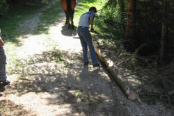
Starting from the loc. Osteria Fontanella (1061 m), will skirt the forest nursery "Mosca" in a northerly direction to reach the "Rossabeghele"("horse lane ", in the ancient Cimbra language), so called because, in times gone by as today, important for the disbursement and stacking of timber dragged out of the nearby woods then with horses, now with tractors.
The whole plain was, during the final phase of the Great War, a very important logistical center for our troops deployed on the Ekar and for the French contingent that held the Pennar line.

Timber escrow with horse
Once you reach the log deposit that usually forms at the beginning of the Rossabegale, bend south and goup, following the forest road, which continues along the Granezza di Gallio valley always on the valley floor slightly uphill until you reach a beautiful example of a "stoan platten" fence(" stone slabs ") near the mouth near Malga Corno (1327 m), arriving at which we face the plain. Turning north now you can see the entire valley just traveled and you can understand why this valley is called "Granezza di Gallio": it is precisely the bell tower of this village that can be seen on the bottom right in front of the jump trampolines with the skis of the Pachstall.

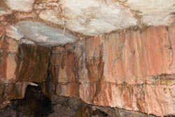
Karst phenomenon
THE FINISH LINE: MOUNT CORNO
From the mouth turn right, now taking the service road to the former quarry that passes behind the monument to the Partisans and that slightly uphill leads us to the top of Monte Corno and its "city of rock" which proposes, although with a smaller extension, the stone labyrinth of the Castelloni di San Marco.
Among the blocks of the ammonite red, the British, between March and November 1918, had prepared a series of positions for cannons, machine guns and riflemen as the last bastion to protect the Venetian plain in the event of an Austro-Hungarian breakthrough along the Barental.
We will then descend following a path traced through the beech forest - whose evocative signpost is represented by ayellow ammonite drawn on the trunks - to the war cemetery of Granezza,where we will trespass into English territory: in thanks for the contribution that the Anglo-Saxon soldiers buried here gave in stopping the last Austro-Hungarian offensive during the " Battle ofthe Solstice", the Italian state gave the English state the ground in which they were buried.
Just outside the shrine, turning left on the paved road, you reach the Monte Corno hut,which is also open in winter.
RETURN TO THE FONTANELLA TAVERN
After passing the large parking lot of the hut you take the first street to the left,to the east, which goes up towards the mouth near the monument to the partisans.
From here you take the forest road, a transit forbidden to motor vehicles,which along the arborata ridge that separates the Granezza di Gallio valley from that of Campo Rossignolo,leads after a couple of kilometers to the bivouac of the "Rossingroba" ("the horse pit"), reached which intercepts the CAI path n.886 that takes you north.
Skirted Mount Gusella with its field artillery positions, you descend rather steeply through the pecceta to reach, in short, the Osteria Fontanella and close the ring.
PHOTO GALLERY OF THE ITINERARY TO MOUNT CORNO
All rights reserved. We accept no responsibility in the event of damage to persons and things that occurred along this route.