Itineraries for excursions

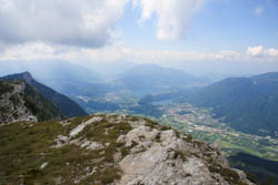
Panoramic view of Levico and Caldonazzo
Route excursion Cima Larici - Cima Mandriolo - Asiago Plateau
HOW TO GET TO THE STARTING POINT
From the center of Asiago you proceed by car following the directions to Trento – Camporovere, left the center of the latter after a few kilometers along the provincial road turns right towards Larici – Val Formica. Traveled the road at hairpin bends, at the junction you keep the right where you can park your car on the roadside or in the vicinity of Larici Refuge.
ITINERARY: Larici-Mandriolo
Technical guidance
Degree of Difficulty: Medium-Easy
Climbing: 400 meters
Max Altitude: 2,049m above sea level
Length: 5 km (return)
Walking time: about 4 hours (tourist gait)
Means: walking
ROUTE DESCRIPTION
The route is divided into a continuous succession of short climbs and descents within high-altitude pastures and coniferous forests. It has been classified as medium – easy as the hiker will face a fairly challenging climb to reach the summit of Manderiolo,a fatigue that will still be adequately rewarded by the panorama.
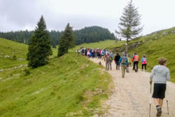
Leaving the car, you take the white road that proceeds in the direction of Malga Porta Manazzo and, after crossing forests of spruce and larch, you arrive in a wide clearing dominated by a wide variety of herbaceous and floristic species typical of the mountain environment and precisely these species, with their scents and their sensory properties, will go to characterize the cheese produced in these areas.
Leaving the dirt road you can, with a short stretch of ascent, reach the ridge and thus get a taste of the panorama on Valsugana.
From the opposite side just 100 meters from the dirt road you can reach Malga Porta Manazzo.
THE POINT OF ARRIVAL: TOP HERDOLO (OR MANDERIOLO)
Then, on the dirt road, after a stretch of coniferous forest, you turn right and you reach the slopes of Cima Manderiolo; the forest completely thins out and leaves the space to a vast expanse of pastures that, along with some rhododendron and here and there a few mugo pines, will accompany the hiker along the last stretch of ascent to the summit. The panorama extends to 360 degrees:you are on the border between Veneto and Trentino,to the east you can see the entire crown of the highest mountains of theAsiago Plateau Seven municipalities while to the north and west there are the peaks of Trentino and the lakes of Levico and Caldonazzo; to the south finally, Monte Verena and a few glimpses on the central highland conca.

Excursion to the Manderiolo
For the return, you walk backwards the last piece of the trail, until you take the road that leads to Malga Porta Manazzo,then continue on pastures and after slight climbs and descents you reach Dosso di Sopra and then continue on the dirt road and return again to the starting point.
GALLERY PHOTO OF THE LARICI TOP ROUTE - TOP MANDRIOLO
All rights reserved. We accept no responsibility in the event of damage to persons and things that occurred along this route.