Itineraries for excursions

Field hen of Galmarara
Itinerary excursion to Bivio Italia and Campo Gallina di Galmarara
INTRODUCTION TO THE ITINERARY
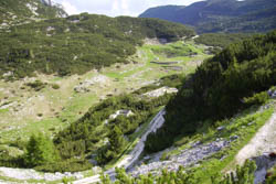
This route winds on an arid and petrous slope in the heart of the so-called "high zone" north of the Asiago basin where the upper peaks of the plateau are located.
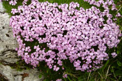
The environment is covered by pre-alpine pastures alternating with outcropping rocks and mugheta. Of particular interest is the presence of numerous karst phenomena represented by large sinkholes, deep chasms and "furrowed fields". Walking you can not help but notice the beautiful flora that surrounds the outcropping rocks that is made up of the lush pink blooms of the Silene aculis, the white ones of the Dryas octopetala and the blue ones of the gentians. These plants are accompanied by numerous dwarf willows including Salix reticulata, which is one of the smallest "trees" in the world. On the other hand, the spectacular blooms of rhododendrons and edelweiss are better known.
Arrived at quota 2055, near the memorial plaque of the Austrian general Mecenseffy the gaze opens considerably on the "high area" of the Plateau and you can observe the highest peaks including Cima XII, the Portule, the Ortigara and the Caldiera.
As in the other areas of the Plateau the environment preserves the signs of the First World War, in fact we find the remains of the Austrian rear (there was the Command District of the VI Infantry Division) which are represented by the various military mule tracks (including the famous Kaiser Karl Strasse), by the entrenchments, by the shelters, by the walls, by the tunnels, by the funicular station, from a field hospital, etc.
The route is ideal for those who want to combine a route of high historical value, without neglecting the many natural, landscape and geological beauties in the area. The excursion is considered medium, passable on foot or by bike.
ITINERARY: Bivio Italia and Campo Gallina di Galmarara
Technical indications
Degree of difficulty: medium
Difference in altitude: 484 m
Altitude-min: 1.614 m asl
Altitude-max: 2.098 m asl
Length: 16 km (round trip)
Walking time: 5 hours
Means: on foot - by bike
HOW TO REACH THE STARTING POINT OF THE ROUTE
The access road open to the public that allows you to reach the beginning of the itinerary faster is the road that goes from Valdassa to Val Scaletta and then to Val Galmarara. Then starting from Asiago we head towards the village of Camporovere and then take the provincial road that leads to Passo Vezzena (n. 349). After about 3-4 kilometers on the right take a dirt road that leads to Malga Galmarara. In front of the hut you can park your car.

Path to Bivio Italy
THE ROUTE TO CAMPO GALLINA DI GALMARARA
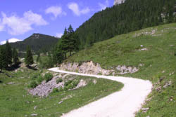
From the Malga di Galmarara take a dirt road, along the valley heading north, towards Bivio Italia. Along the way you can see the Corno di Campo bianco in front and the Cima dell'Arsenale on the left. After climbing a few laps between mountain pine and larch trees, the road flows into the Busa della Pesa where you can take a shortcut that allows you to reach the altitude of the "Tre Fontane" Refuge faster. Continue along the dirt road under the rocky walls pierced by war tunnels of the Horn, the climb is not steep but seems endless because of the many curves.

Rose Silene Acaulis
Continuing we begin to glimpse the Bivouac of the shepherds of Bivio Italia (1987 m) and arrived on site the landscape begins to open considerably on the highest peaks of the Plateau. Resuming the path on the dirt road on the left you head towards the most panoramic point of the excursion where there are the major formations of "furrowed fields". Continue down in altitude leaving the Corno di Campoverde to the south; along the way you meet the Busa del Can, a chasm where snow persists even in summer. Flanking the Colombarone you are approaching Campo Gallina, a large basin that opens in front of you as if from a terrace.
The basin has numerous war testimonies. Continuing south you will find numerous tunnels on the right until you reach the junction of the "monuments", where there is the monument of Archduke Eugene, from which a path branches off that leads to Bocchetta Portule while keeping the road to the left you head back towards Malga Galmarara.
Along the path that leads to Cucco di Portule, on the right at the bottom, you can see Malga Portule; arrived at the Cucco you begin to climb some hairpin bends up to the saddle of Dubiello from where you can see the plain of Asiago. From here the road descends towards the "Busa del Molton" until it returns to Malga Galmarara.
PHOTO GALLERY OF THE ITINERARY AT BIVIO ITALIA AND CAMPO GALLINA DI GALMARARA
All rights reserved. We accept no responsibility in the event of damage to persons and things that occurred along this route.