Itineraries for excursions
 Hiking and walking itineraries: Route to Bocchetta Portule
FEATURES OF THE TRAIL
From the prohibition of transit at the start, the bottom is in excellent condition, to the sighting of the bastion of the Bocchetta, where the path looks a bit stony and uphill, but, after all, it is just a long walk!
HOW TO GET TO THE STARTING POINT
From the intersection of the Millepini Park (located at the entrance to Asiago) you take the provincial 349 to Trento; 12 km from Asiago takes the road to Larici / Portule on the right.
ITINERARIO: Portule mouth
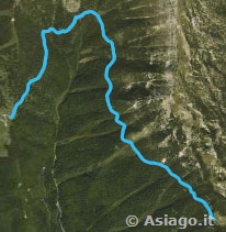
Technical guidance
Degree of Difficulty: Medium
Climbing: 241 metres
Min altitude: 1,674m above sea level
Max Altitude: 1,915m above sea level
Length: 10.7 Km (Round trip)
Walking time: about 4 hours (tourist gait)
Means: Walking, Mountain Bike
After the stretch of hairpin bends all in asphalt, you take to Malga Larici below/Portule, a path that you can walk by car, up to the mouth of the trail 826 (with no transit) to Bocchetta Portule / Cima Portule, well indicated by the CAI, where you can park. This is the actual starting point of the itinerary.
PORTULE MOUTH ROUTE DESCRIPTION
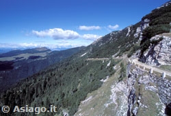
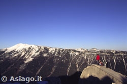
The beginning is well prepared for the walk. The bottom is great, compact; the vision is immediately wide-ranging, albeit in the midst of larches, mugues and firs. Looking up, the Portule wall accompanies the walker from the first step. It's an image that involves and almost rushes to continue, to find out what awaits you after the first curve. The view is free of obstacles, the horizon opens and widens, as you progress, and the trees on the right disappear almost entirely. Above the head, like a strict caretaker, the Portule, in front of the Verena massif, with a hat of clouds, as often happens on all the peaks worthy of the name.

The path very gently begins to rise, but it is almost not detected, so much is the richness of the flowers, grasses and shrubs that adorn both sides of the path: almost a natural botanical garden. There are so many species that it is not possible to enumerate them. Among them reign rare and sovereign, therefore protected, the martagon lily, the aquilegia, the rhododendron, the golden rod... Herbs such as thyme, mint, mauve, wild fennel and achillea (for schnapps) scent the air until intoxicated - surrounded by a sea of mugo. Yes, there is so much, everywhere, it is born and grows even on bare rock, with its typical candlestick shape.
"Larches" is not by chance defined the area: leafy and light sprout here and there in the mugo, the trunk similar to cork, the branches and mighty roots. They are delicate trees in their majesty: many are crashed or dead, but many others born at their feet... who knows if they will survive!
And here is on the right above the escarpment, the shepherd's shed,unchanging for centuries, and, shortly after, theentrance of the path to Porta Renzola,well signposted by the Cai. You overcome it with joy, so much so, and you continue. In short you reach the point where the same Cai 826 trail fork and descends steeply on the right in an hour, towards the Val Renzola. Meanwhile, imperceptibly you go up and the view opens: in the distance the Trentino mountains with the Spitz Verle lookout; in the foreground, to the right, the ridge of the Larches and, at the foot of the Verena in front, the spread of Malga Pusterle and the serpentine of the provincial. Immediately there crosses a memorial stump, a mozza column in memory of the mountain "Toi" perito, betrayed perhaps by fog or a sickness. On the headstone, the inscription: "In these birthplaces ognor attracted, Toi, you turned off".
It is a point where it is detached, and then climbs back into a gentle swinging pattern, always in the midst of mucus, larches, flowers and raspberry bushes. A few rare stones, emerging here and there from the massil, makes you more careful. The Portule always at the side and the mouth of the same name that begins to show, in front. The ascent climbs up, but not that much, only that the stony bottom requires attention. The bastion of the mouth gets closer: the 2 holes dug into the rock look like the eyes of a giant staring hard from up there. The edge of the trail - now being the high altitude and the important difference in altitude - is protected by stone paracarri. If you lean over, you can see the pieces of the logs used by the Austrians to support the bottom of the path, some still intact: great engineers, our old adversaries!
And here is the saddle dug into the rock, here is the declivity that leads to the right at the entrance of the caves of the Mouth. The trail, which is abandoned here, branches, well signposted, towards Cima Portule (Kempel for the Austrians) on the left and continues in front, towards thearea of the Monuments,then that of Galmarara.

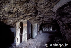
Some tourists have a packed snack in thearea equipped in front of the cave, others arrive, on foot or on Mountain Bike. It is a place frequented by the Bocchetta and why you understand it immediately, just read the indicative wooden and stone tables in front, which illustrate the function of the caves and the strategic importance of the site for the enemy: below, with a difference of 800 meters there was the source Renzola, whose water, pumped with a collection system, with lifting pumps, served to supply the first lines, with a cable car carrying soldiers, ammunition, food, up to the head of the Arsenal through a tunnel practiced in the rock, visible to the naked eye, to Gallina field (the enemy's logistics area, with church, cinema, hospital, shelters, warehouses), up to the Zingarella and the Ortigara.

Entering the caves, after taking a look at the docking of the ziplines and the track for the trolleys, strikes a certain fear: it is an engineering work already carried out by the Italians, for the laying of a 120 mm cannon,before losing the station as a result of the Strafexpedition. Immediately the Austrians built on one side the tank for the water reserve (80 cubic meters), on the other, dug two more holes, for machine gun station. Leaning over, one understands well the strategicity of the place, looming the road to the Term (the old border) and with the Fort Verena in front - the most representative of the Italian forces - and the decisive function it had for the enemy.
It is a destination that can not be overlooked during a holiday on the Plateau,because it is a condensed of meaning and memory of the First World War,as well as a great walk in the high seas. A pause of rest and reflection induces the return, easier because partly downhill, partly flat, up to the starting point. It takes almost an hour less to descend and, despite the kilometres already in the legs, the re-entry is smooth and fast. With relief you drive the small piece of dirt, up to the paved road and from here, to the starting point.
Beppa Rigoni Scit
The two photos above are of: Pierluca Grotto - The photos of the gallery below are by Beppa Rigoni Scit

Gallery photo of the route to Bocchetta Portule
All rights reserved. We accept no responsibility in the event of damage to persons and things that occurred along this route.