Itineraries for excursions
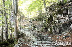
The Calà del Sasso di Asiago
Hiking and walking routes: route for Calà del Sasso
ITINERARY: Calà del Sasso
Technical indications
Degree of difficulty: medium-high
Difference in altitude: 744 meters
Min Altitude: 221 m above sea level
Max Altitude: 965 m above sea level
Length: ca 7. Miles (one way)
Walking time: approx. 3:0 (pace)
Media: walk
HOW TO REACH THE STARTING POINT
To take the downhill route from Asiago to reach the Sasso di Asiago in car following the SP72 towards Bassano del Grappa. Passed the village of Campomezzavia ( 8.5 miles from Asiago) is still a mile turn, at the crossroad, turn left. Proceeding for additional 3.5 km you reach the sign indicating the beginning of the country. At signs, turn immediately right and reach the car park which is located just a few metres away. From there proceed towards the adjacent lawn to begin the itinerary.
Otherwise, for those who prefer to take the path uphill, as shown below, you will reach the village of Valstagna in about 15 minutes from Bassano del Grappa by car or train (BF Resory village-Valstagna station of Bassano/Trento). From the traffic lights on the SS47 Valsugana, from entering the country and follow the signs for the SP73 leading to Foza, cross the bridge over the River Brenta and turn right. After about 100 metres turn left and leaving the village, we reach the first hairpin bend nº 1 and, a mile further along the curve nº 2 where you can leave your car in a small parking lot.
DESCRIPTION OF THE ROUTE
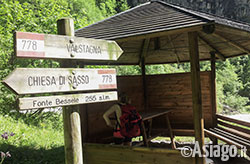
The source Bessele-the beginning of Calà
For the version of Calà, uphill from the above bend number 2, then, walk straight on the stretch of dirt road (trail no. 778 CAI) of about one kilometer, almost flat, between two tall cliffs, which leads to Bessele Source s.l.m 255 (Fontanèa) where a wooden structure welcomes hikers to a refreshments inside offering the possibility to read on an explanatory panel tells the story of the places, deepen the characteristics of the architecture of the staircase and theancient legend of 1638, which States that If two lovers follow the Calà hand in hand, you will love forever.
So far so simple.
Now comes the Nice: the 4444 stairs stairway (Let's face it, we don't have them counted, but we believe) begins.
The extraordinary architecture is among the longest in the world and was built at the end of the 14th century in order to conduct the timber from Asiago to Valstagna safely and mostly independent of gallium and Foza, these countries, which claimed heavy dutyotherwise. In addition to lumber down the time merchandise also and above all people, hence "Alcala" or drop-down. From the viewpoint of Valstagna instead link the Valley-Mountain was known as "road of Stone".
From the first steps, the road takes a considerable gradient and good visitor should try to get your rhythm. Gradually adentra increasingly in dense vegetation and forest rich in colors.
You should pay attention at every step to avoid slipping because the supporting surface in some places can be made slippery by water and MOSS due to rain or moisture present, especially in parts of the route where the vegetation is dense.
The staircase is composed of steps made of stones and pebbles, and, next, the side that was intended for sliding logs, hollow and made of larger stones. In some areas the steps to stop transit of raceways for runoff are also built with rocks and stones.
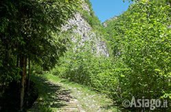
First steps of Calà del Sasso
Along the way, some areas are named specifically, calling features and intrinsic peculiarities of that point. We're talking about, besides the already mentioned Fontanèa also known as Fonte del Bessele, the site of arrival after the fallen timber and refreshment for boschieri III Torneo Franchini, Volta de Majo, or May curve, Fontanèl where there is a water tank made of concrete during the first world war.
Going up you will come to a small flat in the Florentine Valley that descends from horse Jump, known as Pian dee Florence, followed by a steep climb called dee Florentine Limb. Higher sides are approaching clutching the trail among cliffs in places topic selection, followed by another steep climb where probably stood a Linden Tree, theLimb of tajar. Continue up to Santantònì, a place of worship dedicated to St. Antonio Abate. Then you get closer to a massive pillar of rock by the appearance of an ancient tower of a castle, the Casteliér, followed by a deep cavity in the ground, Spiròncia, (or Cùvala) and then of Camin, a narrow passage between two cliffs. With a final steep climb,Arto de Evina, the Calà ends on the plateau of Lanzi in Locality Evina in Sasso di Asiago.
The path is not of the easiest and recommend it especially to those who have some training: not suitable for trekkers improvisation. It's definitely doable even by families with children of school age but starting in the morning, packed lunches or at the bar of stone and returning after adequate break since returning (downhill) presents some difficulties, especially for those who suffer from joint problems (e.g. knees) given the considerable stress.
The journey times can vary widely based on the athletic preparation of each. The return to the Valley is definitely faster.
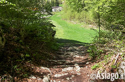
The latest steps of Calà del Sasso
Returning to Calà, the arrival at altitude on the beautiful green lawn just beyond the staircase is equipped with benches and illustrative bulletin boards, certainly gives a great satisfaction after so much effort but should travel at least 500 meters and arriving into the country of Sasso di Asiago in order to enjoy the hike. Just got into town is within easy reach of the Great War Museum, 15-18, and for those who prefer to visit a restaurant, even a few bars. Real end of the path is the Stone Church that is located less than 100 yards from the Museum.
Paul Rumitz, renowned writer and journalist, in 2003 wrote to the Republic a piece entitled The grand old scale:
Quattromilaquattrocentoquarantaquattro , steep steps from beasts, tiring already to appoint them. Depart from Val Brenta, under every Defender peaks, at the point where the Valley-coming from Bassano-it seems split in two at a country called Valstagna, with its wall of old houses of levee. The alert takes the left split and burns in a Flash 810 metres altitude. It's called «Calà del Sasso ", and is one of the most beautiful in the Alps.
Lisa Giovannini Alberto & Maheshwari
MAP LOCATION
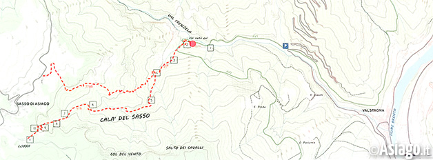
PHOTO GALLERY OF ROUTE FOR CALÀ DEL SASSO
All rights reserved. We accept no responsibility in the event of damage to persons and things that occurred along this route.