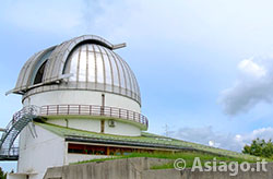
The Astronomical Observatory of Cima Ekar in Asiago
Asiago Mountain Bike (MTB) Itinerary – Astronomical Observatory of Cima Ekar
ITINERARY (MTB): Asiago – Astronomical Observatory
Technical information
Length: 27 Km
Difference in altitude: 600 mt.
Maximum altitude: 1366 mt
Difficulty: EASY
Walking time: 2 hours 30
Easy itinerary for Mountain Bikes (MTB) or E-bikes that crosses the area of the Valbella ski resorts and leads to the Astronomical Observatory of Asiago at Cima Ekar, founded in 1973 and managed by INAF. The observatory represents an important point of reference for advanced scientific research and houses two instruments of great importance: the Copernicus Telescope, with a 182-centimeter diameter mirror (currently the largest optical telescope located in Italy) and the Schmidt Telescope, a wide-field robotic instrument, dedicated to monitoring the sky.
Once you reach Cima Ekar, your gaze opens onto a splendid panorama of the Asiago Plateau, which can also be admired sitting on the characteristic yellow "giant bench", located in a strategic position: an ideal place to stop, take some photos and take a nice souvenir of the trip with you.
HOW TO GET TO THE STARTING POINT
Leaving the Ice Rink, take via Trento-Trieste heading towards the center of the town.
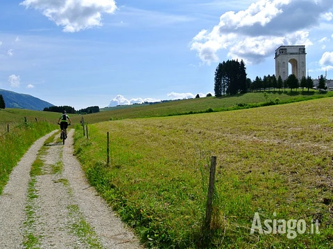
At the second roundabout turn right into Via Matteotti and then after 100 meters turn left into Viale della Vittoria. The avenue leads right in front of the Military Memorial of Asiago, an imposing monument that preserves the bodies of 54,286 fallen Italians and Austro-Hungarians.
For those who want, the Shrine can be visited free of charge respecting the timetables, but remembering that it is not possible to enter with your MTB along the avenue.
ITINERARY DESCRIPTION
 The dirt road that runs along the Military Memorial
On the left of the Shrine, the itinerary continues along a dirt road which, with a false flat course, continues through meadows.
After about 700 meters , turn right onto a grassy cart track that is not very evident that climbs through a meadow with a large tree in the center. After passing the tree, it is possible to see the road that leads to Zocchi more clearly.
After passing through some houses, you will cross the asphalt where you will turn left. Continue 150 meters downhill and turn onto the dirt road called Tilman Street. This dirt road first descends for a few hundred meters and then climbs again. Be careful to ignore all the side roads and continue along the road, which in its final stretch slips into a small valley between two bumps , climbing with an accentuated slope, with a slightly loose but still rideable surface, until it crosses the paved road near the locality of Bertigo.
At the next crossroads, turn left following the signs for the Valbella ski resorts. Reach and pass the lifts and following the road that becomes a dirt road, go up towards Malga Stenfle. Once here, you can enjoy a beautiful view of the plateau with Asiago and Gallio that stand out from the other resorts. From this position it is also possible to see the ski jump of the Pakstall in Gallio , now in disuse since 2002.
After Malga Stenfle, the road continues slightly uphill until it reaches the top near a monument dedicated to the fallen. Leave the monument on the right and immediately after a short descent turn right along the Melago valley passing near a marble quarry.
Very often, as you can also see from the images, in this valley you could find grazing animals, even on the road, but being used to our presence they will not cause any disturbance.
Continue along the main road slightly downhill , ignoring the side roads that you meet, until you take the second road on the right with a prohibition sign near a small clearing. When you arrive near the clearing, be careful because the road is not particularly visible and, taken in a hurry, forces you to quickly change the gears of the Mountain Bike, because it climbs sharply towards the woods. This forest road goes around the mountain for 4 km with ups and downs at times with a loose surface until it crosses the paved road that leads to the astronomical observatory.
Just before arriving at the Cima Ekar observation station, located at 1366 meters above sea level, you can see on the right the beginning of a nature trail made in memory of a science teacher of the elementary schools of Asiago, the path of the teacher Patrizio, who taught many generations of children with passion; This circular route (which returns to the starting point) can be added to the main one, it can be covered entirely by bike or as a starting point for a second trip, perhaps on foot.
From here you cancontinue uphill for just over 1 km until you reach your destination. After resting a bit and admiring the surrounding landscape , start the descent by following the Observatory road for a few meters until you pass another building adjacent to it. From here the road returns to being unpaved along the ridge of the promontoryThis ridge is called "the windows on the plateau" because there are various points where the trees are lower and open natural "windows" from which to see Asiago, including the Shrine from where the itinerary began.
After passing the Malga di Campo Costalunga, near the arrival of an old ski lift, keep left and descend along the dirt road. Continuing on, pay close attention to the bottom of the road, which is quite bumpy, and to the fence gates that delimit the areas reserved for grazing animals. If there are closed fences along the road, you can still continue the itinerary, opening them and always remembering to close them as they were found.
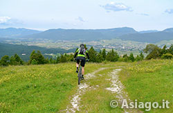
View of the Plateau near the observatory
Cautiously continuing on your mountain bike (MTB) along the descent, turn left onto the Tilman path (indicated by the relevant sign) until you cross the road traveled on the outward journey in Bertigo. At the crossroads, in order not to take the same route as the outward journey, turn left and continue on asphalt for about 800 meters until you turn right on a side street near the Snoopy disco.
After a slight climb you reach the Pennar district where you can stop at the Pennar dairy to buy dairy products. Once you have refueled, the itinerary now comes to an end by descending until you reach the main road that leads back to Asiago and the starting point of the itinerary.
In collaboration with Altopianobike and Free Time Asiago
ROUTE MAP
PHOTO GALLERY OF THE ASIAGO ITINERARY – ASTRONOMICAL OBSERVATORY
All rights reserved. We accept no responsibility in the event of damage to persons and things that occurred along this route.


