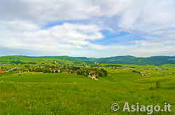
Asiago seen from the road towards the fort Interrupted
Mountain Bike Route (MTB) Asiago – Zebio – Forte Interrupted
Mountain Bike (MTB) route to do when you have some training on your legs because there are challenging points where you have to push on the pedals. The route is mostly on dirt roads, except for the first and last stretches that develop on the inhabited areas around Asiago. The commitment is rewarded by the places you cross: the Val di Nos, very pleasant for its false plane in the woods and especially the areas of Monte Zebio and Forte Interrotto with their historical significance.
ITINERARY (MTB): Asiago – Zebio – Forte Interrupted
Technical indications
Length: 30 Km
Difference in altitude: 970 mt.
Maximum altitude: 1674 mt.
Difficulties: MEDIUM-DEMANDING
Walking time: 3.5 hours
HOW TO GET TO THE STARTING POINT
The start of the MTB itinerary is at the Asiago ice stadium, a strategic place to get there by car, park without problems and leave with your mountain bike. Leaving the parking lot, make 50 meters, and take via Trento and Trieste.
ITINERARY DESCRIPTION
The road descends arriving at a roundabout where you continue straight passing through the central area of Asiago where there is the Town Hall and the beginning of Corso IV Novembre, the main street normally for pedestrian use. Continuing, you reach a second roundabout where you will have to turn left into Via Cesare Battisti which will then become Via Cinque. After about 600 meters there is a bifurcation where the barracks of the State Forestry Corps is located.
Keep right towards the Ebene district, along the fence of the airport and continue for about 1 km arriving at an intersection where you will have to turn right and after 50 meters, left on via Villa Rossi. After about 400 meters turn left onto a road that in its central stretch is unpaved and then return asphalted. When the road joins with another, continue straight and face a tear of about 100 meters that leads to an intersection. Turn left and take the direction of the Gastagh hill.
After a few hundred meters you will pass in front of a riding school and then the road will enter the Val di Nos.
Along the valley it is possible to visit on foot an educational area formed by two paths that explains, through different stages, the ecosystem of the forest.

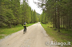
Along the Val di Nos
The crossing of the Val di Nos on the mountain bike is pleasant as the road, about 6 km long, is in false plane up to the final part, where the slope is pronounced until it meets two hairpin bends that lead to a junction. On this junction, turn left and continue for about 1.7 km, leaving a dirt road on the right until you reach the junction of the Scoglio Bianco. From here turn right and continue for another 1.5 km until you reach Malga Zebio, where you can taste the award-winning cheeses of the malga.
The place deserves the temporary abandonment of your MTB to go and visit the trenches and tunnels of Mount Zebio, one of the most interesting areas of the open-air Ecomuseum of the Great War. Precisely in this area on June 8, 1917 - perhaps due to lightning - 160 died from the explosion of a mine, between soldiers and officers.

Fort Interrupted
The second important stage of the itinerary is that of the Interrupted Fort. To reach it return by the same road for 1.5 km and, at the junction of the Scoglio Bianco, turn right and continue downhill for about 2.3 km. At a junction , keep right and continue for a challenging up-and-down that turns around Mount Zebio for about 2.5 km.
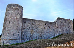
After this distance, turn left and continue flat leaving out two lateral ones, respectively on the left and right, until you reach the Interrupted Fort. The fort in recent years has undergone a major renovation that has led it to look very much like its origins. The name Interrupted does not mean, as the word says, a work interrupted in its construction, but derives from the mountain that dominates it, the Interrupted Mountain.
It should be noted that the term "Interrupted" is an Italianization of the Cimbrian term Hinterrucks which means summit located to the north, precisely because it is located in the northern area of the Plateau. After the visit to the fort can begin the descent to Asiago on the paved road that descends from the fort.
Be careful not to get caught up in the descent, since after the hairpin bends you have to turn left for a dirt road in the direction of the San Domenico district until you return to the center of Asiago.
In collaboration with Altopianobike
ROUTE MAP
PHOTO GALLERY OF THE ITINERARY CESUNA - MONTE CENGIO - FORTE CORBIN
All rights reserved. We accept no responsibility in the event of damage to persons and things that occurred along this route.