Sunday 15/7/2018 at 07:00
Sport

Traditional gear with Marathon in Biancoia locality, Conco, Asiago plateau
Sunday, July 15 2018, in Biancoia village of Conco, Asiago plateau, will take place on the8th March Edelweiss and 7th Marathon Memorial Giuliana Crestani, a non-competitive running event on the mountain path, with a Altitude ranges from 600 meters and 1200 meters, with routes of 6, 12, 20, 32 and 42 km.
The routes are passable from 7.00 a.m. to 16.00 hours with departures from 8.00 a.m. to 7.00 hours routes from 32 and 42 km and from 7.00 p.m. to 9.00 for paths up to 20 km, directly from Biancoia.
DETAILS 8 MARCH EDELWEISS
◆ Organization: Pro Conco (to contact the Pro Loco of Conco click the buttons at the bottom of the page)
◆ Date of the event: 15 December 2018
◆ Event location: Conco Biancoia
◆ Name: 8th MARCH EDELWEISS and 7th Marathon Memorial Giuliana Crestani
◆ Departure, arrival and registration at: Biancoia by Conco
◆ Departure times: from 7.00 to 9.00 for routes up to 20 km; from 7.00 to 8.00 for routes from 32 and 42 km
◆ Practicability itineraries: the routes are passable from 7.00 to 16.00
◆ Number ristori: 8 + 2 points of water
◆ Location: 6 and 12 km for everyone-20, 32 and 42 montano
◆ Altimetry: departure at 1100 m, minimum height 753 m-maximum altitude 1287 m
The event is valid for competitions NSIA, IVV, Winged Foot, Women Podiste, marathons in Vicenza, Italy.
Has the obligation to respect the rules of the Road Runner
The NSIA demonstration approved by CP 27.02.2018 with footnote 065 of Vicenza.
For matters not covered in this programme, the rules of the organic regulation the demonstrations NSIA.
INSCRIPTIONS
◆ Groups
Registration for groups will close at 22.00 on the Friday before the event (Tel. )
◆ Individual
Registration for singles will close the morning of the event, until the time of departure
PARTICIPATION FEE
- for only those services March: 2.00 euros (affiliated NSIA), 2.50 euros (not affiliated) *
-
2.00 euro (affiliated NSIA), 2.50 euros (unaffiliated) for routes up to 20 km
-
4.00 euro (affiliated NSIA), 4.50 euros (unaffiliated) for routes 32 and 42 km
* These amounts are not contributions subject to VAT pursuant to article 4 paragraphs n° 2-4-6 of 633/72 and subsequent DPG without prior notice; the above contributions are finalizzati to the realization of the event is the subject of this booklet live implementation of institutional purposes in accordance with Art. 2 paragraph 1 letter A-B of Decree No 490/97 and 3° paragraph of Art. 148 of the tax code
PATHS
◆ LOCATION 6 KM (suitable for all)
Actual distance: 6.6 km (10.3% asphalt)
Culmination point: 1287 m (With Flash)
Minimum height: 1100 m (Biancoia)
Ristori # 1
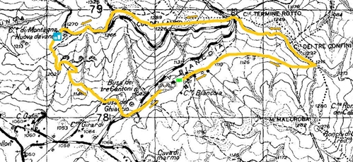
◆ LOCATION 12 KM (suitable for all)
Actual distance: 13.3 km (10.1% asphalt)
Maximum height: 1216 m (Col dei Tre Confini)
Minimum height: 922 m (Valleranetta)
Ristori # 3
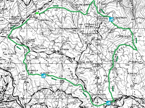
◆ LOCATION 20 KM
Actual distance: 21 km (17.7% asphalt)
Culmination point: 1,287 m (With Flash)
Minimum elevation: 793 m (Contrà Bohemian)
Inn: # 4 + 2 water points
◆ LOCATION 32 KM (mountain road)
Actual distance: 32.7 km (17.8% asphalt)
Highest altitude: 1,220 m (junction Malcroba)
Minimum height: 753 m (Fontanelle)
Inn: # 6 + 3 water points
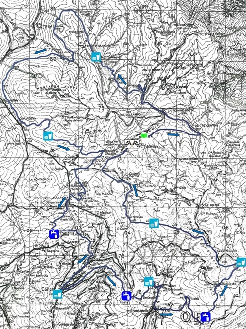
◆ LOCATION 42 KM (mountain road)
Actual distance: 42.0 km (13.8% asphalt)
Culmination point: 1,282 m (Mount Malcroba)
Minimum height: 753 m (Fontanelle)
Refreshments: 7 + 3 water points no.
All rights reserved.


