Itineraries for excursions
Circular itinerary from the Ghertele Ecomuseum.
ITINERARY: Ghertele Ecomuseum Tour - Malga Pusterle
Technical indications
Degree of difficulty: Easy
Distance: 5,6 km
Difference in altitude: 282m
Altitude: 1300m asl
Walking time: 1h 50 minutes
Means: on foot
INTRODUCTION TO THE GHERTELE ECOMUSEUM ITINERARY - MALGA PUSTERLE
The itinerary leads to the discovery of the town and the Malga Pusterle located within the Municipality of Roana. Very interesting tour from a landscape and historical point of view. it is suitable for people and families who want to spend a day immersed in an environment rich in pastures, alpine pools and animals that inhabit the hut.
HOW TO GET TO THE STARTING POINT
Starting by car from the square of the Asiago ice stadium, proceed on the SP 349 in the direction of Trento. Once in Camporovere, after the church, follow the signs towards the town of Vezzena - Trento. Continuing along the main road for about 10 km, you reach and pass two hotels: the osteria alla Tagliata and then the osteria Ghertele. Here you take the dirt road on the left (at the beginning of which you can leave the car) with signs for Malga Pusterle.
THE ROUTE
The walking route starts immediately after the tavern Ghertele. On the left you take an old military mule track that crosses a small bridge over the Assa stream. Immediately after 50m take the path on the left that goes up along the lawn. it is the nature trail of the ecomuseum that is initially easy to identify as you can follow the signs that tell the story of the Ghertalina del Ghertele.
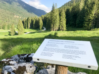
Ghertelina del Ghertele
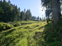
Proceed uphill until you cross again the dirt road that you have to cross, to continue uphill along the path. This piece of road takes place inside the pasture bordered by the forest on the left and then, once crossed the road, continue only on the pasture. The path is well identifiable and difficult to make mistakes. We always walk in the pasture, every now and then we meet some bench to rest but the visual space allows you to easily spot the signs of the history of Ghertalina that accompany us along the way. At the fourth sign, you notice that the path goes into the woods and proceeds the slight descent until it plunges into the spruce forest. From this moment on you will begin to hear the relaxing sound of the movement of water inside a stream. In fact, you get to a bridge but you have to be careful because with the passage of time the wooden bridge has deteriorated. Better to cross the stream to the left and proceed straight inside the forest until you get to the pasture and start a short climb.
Out of the pecetta you can see again the hairpin bend of the military road. You walk straight towards the hairpin bend but leave it on the left and follow the new uphill track traced by forest vehicles during the exforestation of the timber felled during the Vaia storm of 2018.
Along this climb you will come across numerous flowers characteristic of the pasture such as buttercups and aquilegies. Walking you still keep close to the milestone that you will find for the inner path to the left of our path. Arrived near the grove you dive inside following the track. Once you reach the small stream, you pass, and keep to the right, immediately leaving the woods to return to the pasture and, keeping to the left, climb until you get to see another bridge with a large green sign. Arrived on the spot you can stop to read the information of the sign where there are explanations of how the malga works, a typical Altopianese structure. After a short break, continuing inside the uphill pasture, you reach the military road again. Here we notice the sign of the Ghertele ecomuseum.
From this moment on you proceed along the main road until you reach a stable and then the Malga Pusterle.
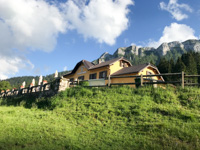
Malga Pusterle
The structure is a unique building renovated in 1999 suitable for the production and maturing of cheese and to accommodate the Malghesi who in this period are transferred to live here.
The hut has also been used for the service of agritourism and therefore passing visitors can stop to eat and taste the products and typical dishes that this structure makes available. In fact, it has numerous outdoor tables where you can refresh and rest and then resume the journey.
THE RETURN
Leaving the hut, you can continue uphill towards the dirt road walking until you reach the second hairpin bend. Here you have to evaluate the time available. Our path leaves the hairpin bend to continue straight in the pasture towards the building – source with the puddle that can be glimpsed from the hairpin bend itself.
For those who want to take a longer walk can instead continue straight and make two more hairpin bends. At the fourth hairpin bend a road crosses with a ban on cars. Leaving the main road and walking straight along the crossed road for another 10 km you arrive at the Roana pond. Instead continuing along the main road for another 5 km and then making the hairpin bend you can reach the Casare di Mandrielle and then we still recommend returning to the same road. In both cases, the return time must be evaluated.
Arrived at the source with the alpine pool you return through the pasture to the Pusterle hut and head towards the board near the military road. In this stretch of route you can admire the many flowers that abound inside the fescue pasture. In spring, numerous golden buttons adorn the pasture mixed with the heady scent of thyme that you can smell while walking. The most attentive eye and ears can detect the presence of animals hidden in herbs; here with a little luck you can hear the pìch-pì-pìch of the quail that four four hides so as not to be seen.
Once back to the dirt road you begin to descend towards the return road without ever abandoning the main road that with a series of hairpin bends will take us back to the beginning of the route. Interesting in this downhill stretch is the water tank that is located on the roadside certainly built during the period of the First World War and today useful for watering grazing animals.
Even the nature that surrounds the road is of particular interest, in addition to the spruce some larch and numerous beetles decorate a bright green and in spring yellow the path downhill.
Almost at the end you cross the path taken uphill and then reach the starting point in Ghertele.
© Asiago.it REPRODUCTION RESERVED
PHOTO GALLERY OF THE GHERTELE ECOMUSEUM ITINERARY - MALGA PUSTERLE
All rights reserved. We accept no responsibility in the event of damage to persons and things that occurred along this route.


