Itineraries for excursions

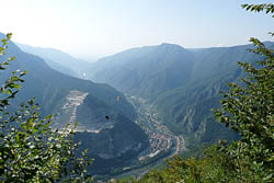
Panoramic view of Brenta
Route excursion on Mount Cornone
INTRODUCTION TO THE ITINERARY
Foza,as well as the entirePlateau of the Seven Municipalities,was completely upset by the First World War.
Everywhere are still clearly evident the signs left by more than four years of fighting, including the area of Mount Cornone: although semi unknown to most, it has coated, even as recently emerged after the new publication of Paolo Volpato "On theedge of the abyss" one of the strategically importantpoints of the Italian front .
This imposing rock horn that stands out over Valsugana was in fact thelast strip of Highland and Italian land on which our army had to stick with its nails and teeth after the collapse of our advanced lines, both in November-December 1917 and in September 1918. The proposed route leads the hiker to a safe visit to one of the most "bold" and significant places in the battlefields.
The route is ideal for those who want to combine a route of high historical value,not to mention the many natural and geological beauties present in the area. The hike is considered easy, walkable and apart from a very small stretch of ascent between Mount Cornone and sasso Rosso,where it is advisable to go down, even by bike.
ITINERARY: Mount Cornon
Technical guidance
Degree of difficulty: easy
Climbing: 84m
Altitude-min: 999m above sea level
Altitude-max: 1,083 m above sea level
Length: 8 km (round trip)
Walking time: 4 hours
Means: walking - by bike
HOW TO GET TO THE STARTING POINT OF THE ROUTE
The starting point of the trail is located at the center of the municipality of Foza at an altitude of 1083 m. near the center of the village where you can park, not for a fee, and the presence of numerous bars and a grocery store give the opportunity to stock up on all the comforts necessary for the daily excursion. For those who enter the Plateau coming from the Valdastico Highway (Piovene-Rocchette exit), following the directions to Asiago,through the SS 349 "State of Cost". Arriving in Asiago we continue to Gallio and then to Foza. Those who come from Asiago must instead follow the directions to Gallio, Foza. A fortnight after passing the village of Asiago, you will reach Foza.

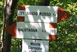
Signage route altitude 1065 m
THE ACCESS ROUTE TO MOUNT CORNONE
It starts from the center of Foza (Vusche : ancient place cymbro) near the municipal building. A visit to the adjacent Foza Museum is desirable before departure. In addition to the Foza sheepsection, there is also a section dedicated to the Great War. On the first floor, an interactive exhibition has been created in which you can have an overview of all the battlefields and better understand the importance of the area you are about to visit.
We walk the first part of Via Turba, a road dedicated to General Euclid Turba who died on the Castelgomberto,in the area of the Melette di Foza. Arriving in the area"capital"near the monument to the Alpine,a work entirely made with grenade shards dating back to the First World War, you take to the left taking the Staich; ancient path already named in notary acts of 1531; that will lead us to Valvecchia,from here you go up to the contrada Ori-Biasia,past the small group of houses that composes it, you take the trail that in a few minutes will take us to Mount Cornone.

Route Italian area
THE POINT OF ARRIVAL: MOUNT CORNONE
After about an hour's journey, partly shaded, you arrive near the spur of rock overlooking the Valsugana to the south. Here a tombstone under a cross recalls the immense efforts made by Italian troops to resist the Austro-Hungarian assaults. I went down just below that area you can admire the Brenta River and in the background the lowland plain.
Once you have admired the picturesque view you can return to the starting point by retracing the path of the first leg; or after a hundred meters, at the crossroads with the path cai No. 781 hold the right and follow to Sasso Rosso, from the namesake malaga take the road north to contrada Carpanedi and from here to the left for the path cai No. 800 that will take us back to the Village Square. Itinerary slightly longer than that of the first leg, but that will allow us to discover other hidden corners of the country.
GALLERY PHOTO OF THE ROUTE TO MOUNT CORNONE
All rights reserved. We accept no responsibility in the event of damage to persons and things that occurred along this route.