Itineraries for excursions
Itinerary excursions and walks Malga Verde.
ITINERARIO: Malga Green Route
Technical guidance
Degree of difficulty: Easy
Length: 6.5 km
Positive difference: 200m
Maximum altitude: 1282m above sea level
Minimum altitude: 1090m above sea level
Walking time: 2.5h
Means: on foot or with MTB
INTRODUCTION TO THE ITINERARY
The itinerary takes us to discover the pastures and woods surrounding Malga Verde,a civic-use farmhouse owned by the cives of the former municipality of Conco. The area is interesting because of its location, close to the south-eastern sector of thePlateau,and for the extensive beeps that surround the resort, forest formation not affected by the damage of the First World War and the subsequent reforestation that characterized many forests of the Plateau, however, there are also in this area aspects related to the Great War.
HOW TO GET TO THE STARTING POINT
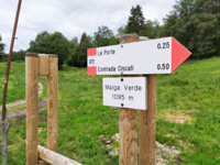
Starting by car from the forecourt of the Asiago ice stadium,we proceed along SP 78 in the direction of Bassano del Grappa. Once you arrive at the Galgi Bocchettaresort, turn left to take the Lastaro Valley. After the residential area you will meet Malga Verde,located just along the road that leads to Rubbio. it is possible to park in front of the buildings of the farm or, alternatively, on the right side where there is a 50m spread after the farm.
The estimated time to reach Green Malga from Asiago is 12-15 minutes.
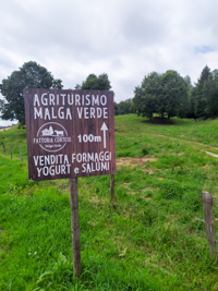
Farm Malga Verde
GREEN MALGA PATH
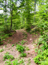
Leaving the car near the farmhouse, we take the path CAI 872 that rises from ciscati and goes into the woods passing right to the side of Malga Verde. You now walk inside extensive bee beans treated at ceduo, the timber from these woods is in fact periodically cut to be distributed to the local population. When we reach the first junction, instead of following the CAI path on the right, let'stake the left deviation instead. After passing a doresta area affected by crashes following the Storm Vaia of October 2018, we will soon reach the ridge of Mount Malcroba that overlooks the ski slopes of The Biancoia resort,side valley of the wider Val Lastaro where the pastures of Green Malgagravitate. These areas in 1918 became very important places of rear-lined side during the battles of the First World War,were in fact set aside in the area numerous departments and in these places were also located numerous batteries of field artillery with the aim of both to block the road to the Austro-Hungarian division Edelweiss (whose attack plans included a descent on the Venetian plain right through the Conco Mountains) and to protect the western flank of the Mount Grappa massif, clearly visible to the east on clear days.
We then continue until we reach the top of Malcroba (1282m slm, the highest point of our route) from which, if necessary, you could quickly return to the farm by following the forest road on the right (intercepting the CAI trail). At the crossroads we take the left road,passed which immediately meets another crossroads: here we now take the right deviation (leaving the CAI path again). Several species of flowers follow each other in this area, from the intense flowering of snowdrops and spring bells in March we move to the carpet expanses of bear garlic in April to theblooms of cyclamines in the summer.
In the following we come near another intersection, where five roads intersect: we take the road to the northeast (recognizable by an always open lock) that after 300m leads us to the crossroads of pian de le Stele:at this point, observing the panorama through Vette Feltrinethe practised language that opens between the begne, you can admire the landscape that looks at the rugged northwestern bastions of Mount Grappa.
From Pian de le Stele we take the road that continues to the east, always walking inside vast beech trees but apparently different from the previous ones: in this stretch of forest you walk in fact between columnary beech trunks, the management of the forest here is different, the beech has been converted to the highfust and is therefore more majestic than the woods crossed previously. At the end of the descent we walk a short stretch of pecceta (an obvious spruce plantation that stands out after the monotony of the beeps): we are in the valley of the Resbech, place of clear cimbra origin, which we abandon to go south. Out for a short stretch from the woods, you can admire around noon the village of Rubbio and, far away, the Po Valley plain, in front of us stand out instead the questionable palaces of locality Le Laite,to the right of the road you can finally notice a series of quadrangular excavations,evident sign of artillery positions always dating back to the First World War. Arriving at the picnic spot of Colle Zolina (where you can possibly stop, there is also a fireplace), we climb along the paved road that leads to the apartments of the Laite - Mount Cogolin (in this stretch you follow the hiking route of "the ring of the Three Borders"). Here, from the parking lot of the residential complex (where you can possibly divert south for a short stretch to admire the wide panorama back towards the plain), you always follow the path of the Three Borders and then resume the path CAI 872 that, along the wide pastures of the valley, leads us to the artificial invader of the Green pond. Now on the roadside, you will soon return to the farm.
© Asiago.it RESERVED REPRODUCTION
GALLERY PHOTO OF THE MALGA GREEN ROUTE
All rights reserved. We accept no responsibility in the event of damage to persons and things that occurred along this route.


