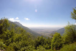
Panoramic view from the Cost
Itinerary for Mountain Bike (MTB) Caltrano – old Cost – Monte Cengio – Forte Corbin - Giro delle malghe
Very challenging itinerary for length and difference in height that starts from the plain and explores the southern part of the Plateau. It is possible to divide it into two days with overnight stay at the Rifugio Bar Alpino to make the tour less extreme.
ITINERARY (MTB): Asiago – Scoglio Bianco – cima Caldiera – val Gamarara
Technical indications
Length: 68 Km
Difference in altitude: 2750 mt.
Maximum height: 1490 mt
Difficulty: very difficult
Walking time: 9 hours
ITINERARY DESCRIPTION
The departure is from Caltrano at the parking lot next to the cemetery which is located near a large roundabout along the main road coming from the highway.
From the parking lot go towards the roundabout and head towards the village of Cogollo del Cengio.
After about 1 km, in Mosson, turn right towards a dirt road that runs parallel to the main road.
After the cycle path begins the old Cost that climbs for about 9 km with a slope never too high until it crosses the road of Monte Cengio.
From here, turn left and climb for a few hundred meters to Piazzale Principe di Piemonte.
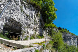
From the square starts on the left the famous and spectacular road of monte Cengio with tunnels on the mountain and passages overlooking the plain.

Road of perch of Monte Cengio
Pay close attention in covering this stretch avoiding getting on your bike if you are not very skilled, a mistake along this route could be fatal.
This stretch is not very long and leads to the Rifugio Granatiere where you can make a stop and, if the timing allows, even a visit on foot on the other side of the path, always overlooking the plain with the tunnels that run around Monte Cengio.
Continuing with the itinerary, from the refuge go up the dirt road that leads to the top of Monte Cengio for 100 meters up to a hairpin bend where you can continue straight towards a cart track in the woods.
The cart track after a part on a slight slope, descends for a short stretch and then goes up reconnecting with the paved road of Forte Corbin.
At the intersection of the road turn left and continue for 2.3 km to the fort.
Ten meters from the entrance gate of the fort starts on the right a path (trail sign 804) that climbs with some steps.
After passing these steps, you climb through the woods until you climb a meadow that will be crossed until you meet the dirt road that will continue downhill for 2 km to the asphalt. Crossing the asphalt turn right and go up towards the church of Tresche Conca, from here get off and reach Cesuna along the old Strada del Trenino.
From Cesuna climb through an articulated path that passes under the ski lifts of Monte Zovetto, the capital of S.Antonio, Monte Lemerle up to climb towards the Rifugio Bar Alpino.

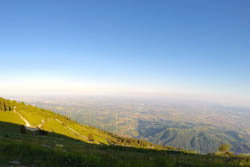
Panoramic view from the mountain hut road
From the Rifugio Bar Alpino where, as mentioned above, it is possible to stay overnight if you decide to separate the itinerary in 2 days, go back for about 100 meters and take towards the former Malga Lovarezze and the Baito Caltrano and then descend towards Asiago passing through the Baito Torle. The descent is very long and fast up to baito Pria dall'Acqua where you will turn right taking the climb towards Monte Corno.
Once at Monte Corno, near the hillside towards the plain, turn right for Malga Mazze Superiore. Here the climb is accentuated up to the former Malga Cima Fonte and the homonymous summit.
At the end of the climb you descend crossing the classic road of the huts with a view of the plain.
Head towards Malga Foraoro and, near the junction that goes up towards the malga, turn left, crossing a barrier that serves to limit vehicle traffic .
From here begins a long dirt descent, sometimes challenging, called "firebreak" that leads to Caltrano, the starting point of the itinerary.
ROUTE MAP
PHOTO GALLERY OF THE ITINERARY CALTRANO – VECCHIO COSTO – MONTE CENGIO – FORTE CORBIN - GIRO DELLE MALGHE
All rights reserved. We accept no responsibility in the event of damage to persons and things that occurred along this route.