Itineraries for excursions
Itinerary for semi-flat walks, discovering a place rich in a precious but rare asset in the Plateau: water
ITINERARIO: Water Trail - Enego
Technical guidance
Degree of difficulty: Easy
Length: 7.0km
Positive difference: 259m
Maximum altitude: 782m above all
Minimum altitude: 728m above all
Travel time (approximately): 2h 50min
Suitable for: Family, Trekking, Nordic-walking, Running
What to see: The districts of Valdifabbro and Coste, the cave of Val Dicina, the view of the Brenta Canal
Fund: Asphalt road, dirt road and trail
PATH FEATURES
The Water Trail,one of the beautiful gentle mobility routes of the Municipality of Enego,leads to the discovery of the districts of Valdifabbro, Coste and Valdicina,to the south of the country.
It is an easy route suitable for all,which crosses places full of charm: the Valdifabbro,where the remains of ancient forges evoke ancient times, when here it melted and beat the iron with hammer and anvil; the contrada Coste,which fascinates with its ancient dwellings and characteristic terraces clinging to the side of the mountain on the Brenta Canal; and Valdicina,a real oasis of peace with water source,rare and precious good in the Plateau.
The itinerary, for its features, lends itself well to trekking, Nordic-walking and running,or more simply for a nice family walk.
Signs
Along the Water Trail you will find several signs marking the route, with QR-Code to be framed with your smartphone in order to listen to the audio guide and discover other details and curiosities about the places of Enego.
HOW TO GET TO THE STARTING POINT
Theroute of the Water Trail has as its starting and arrival Piazza San Marco,in the center of Enego.
If you arrive from Asiago,to reach Enego you just have to follow the Provincial Road 76,passing through the center of Gallio, Foza,the famous Valgadena bridge,one of the highest viaducts in Italy and Europe, and the characteristic hamlet of Stoner.
Those arriving from Valsugana will be able to reach Enego by taking the SP76 Valgadena to thePrimolano-Asiago-Enego exit and then following the directions to Enego.
DESCRIPTION OF THE DOLCE FURNITURE ROUTE "WATER TRAIL"
The Water Trail starts from St. Mark's Square in Enego. Sentiero dell’Acqua With the Cathedral of Santa Giustina behind and the Scaligera Tower on the left, you will have to proceed south and with a gentle ascent via Beato Murialdo,then quickly descend to the first houses of Via Valdifabbro.
At this point, you will have to abandon the main road and, holding the left,walk a secondary route,which will first be paved and then dirt, popping out just before the hamlet of Coste.
Walking through the remains of the ancient forges of the Valdifabbro,you will almost feel the incessant beat of the hammers on the anvils of the blacksmiths,who here once worked by hand the iron that was made from the minerals brought to Enego from the mines of Trentino with the flocks of sheep.
The contrada Coste will also captivate you with its ancient dwellings and the architectural terraces that develop along the side of the mountain on the Brenta Canal,between dry walls and"vanédes"cultivated up above the steepest cliffs.
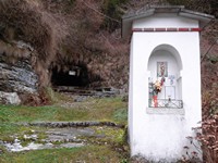
From the coasts,the path will continue first flat and then downhill to reach Valdicina,where with a short detour you can visit the eponymous cave,with the spring and the ancient stone washers.
This place for centuries has been of paramount importance to the inhabitants of the neighboring districts and beyond, who came here to wash their clothes, to water the animals or simply to stock up on a rare and precious commodity in the Plateau,thatis, water.
Due to its karst nature,in fact, the Plateau has a soil that drains thewater into deep cavities that flow into the caves of the valley floor,such as those of Oliero or Bigònda,not allowing it to stop at the surface. There are exceptions, however, as in Valdicina,where a vein of water from Marcesina through underground caverns, narrow tunnels, siphons, ducts and narrow canyons, manages to flow into this precious spring.
Visited the Cave of Valdicina,you will have to return to the fork and cross the bridge over the valley,then follow the road that leads to Valgoda. You will then have to abandon the road at the beginning of the ascent,where you will take a path that descends to the Val Comuna and leads to the bottom of the Valdicina,
From here go up on the opposite side, until you come out on the paved road on the way,at the level of The Coast of There.
If you cross these places you will meet a beautiful lady who will do anything to convince you to follow her, do not do it: it is definitely the Facina,an evil witch who, according to local legends, kidnaps people, especially children, makes them out of their senses and makes them blind or lame.
But don't worry, it is said that, to escape his evils, there are effective remedies, including that of wearing a wool T-shirtin reverse under his clothes.
We can understand the origin of this myth: the Fadaf is nothing more than the personification of an annoying cold,caused by the cold air currents that descend from the Col dei Guzzi and the Dori.
Between wonderful scenery and ancient beliefs, you will retrace the itinerary until you reach the last houses of Valdifabbro. From here, a flat path will take you back to the main road,which you will walk back to Enego.
Sweet mobility project: seven itineraries for easy walks in Enego
The seven routes of the sweet mobility project of the Municipality of Enego
The Water Trail is one of the gentle mobility routes promoted by the Municipality of Enego for the development of a slow and sustainable tourism:a project that aims to rediscover, through suggestive walks,the natural, historical and cultural beauties of the territory.
Enego's gentle mobility itineraries start comfortably from the village square and are suitable for everyone,from families who want to spend a day outdoors, to trekkingenthusiasts, sportsmen and naturelovers.
In all, Enego's gentle mobility paths are seven and lead to the discovery of the often little-known places,linked to the ancient history of the country, captivating visitors with interesting curiosities and enchanting views.
You just have to choose your favorite itinerary and set off to discover Enego:
© Asiago.it RESERVED REPRODUCTION
All rights reserved. We accept no responsibility in the event of damage to persons and things that occurred along this route.


